

Freeze Watch issued for North Georgia: Blast of colder air expected
Monday evening foreacst
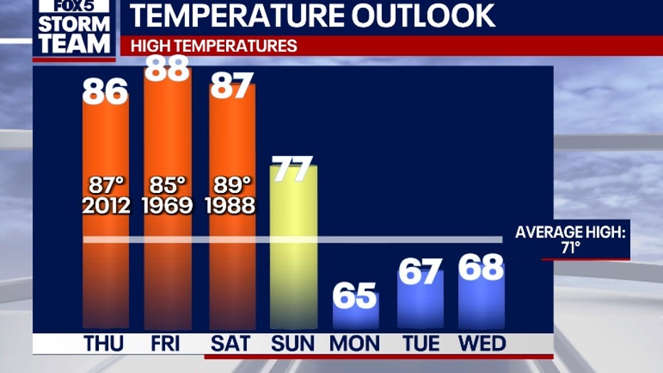
The storms are moving out and the sunshine is poised to return. Also returning are much cooler temperatures. Here's the latest from the FOX 5 Storm Team.
ATLANTA - Despite the unusually warm weather last week, the cold temperatures are not yet done with North Georgia.
A Freeze Watch was issued for portions of central and North Georgia from late Tuesday night through Wednesday morning, warning that sub-freezing temperatures could damage crops and sensitive vegetation.
What we know:
The advisory, released Monday afternoon, includes areas along and north of Interstate 85, covering cities such as Rome, Dalton, Cartersville, Blairsville, and Carrollton. Forecast lows are expected to range between 28 and 32 degrees in affected counties.
"Frost and freeze conditions could kill crops, other sensitive vegetation and possibly damage unprotected outdoor plumbing," the National Weather Service wrote in its alert. "Take steps now to protect tender plants from the cold."
Counties under the Freeze Watch include: Dade, Walker, Catoosa, Whitfield, Murray, Fannin, Gilmer, Union, Towns, Chattooga, Gordon, Floyd, Bartow, Polk, Paulding, Haralson, Carroll, and Heard.
Timeline:
The Freeze Watch is in effect from 2 a.m. to 10 a.m. Wednesday and includes counties across northwest, north-central, northeast, and west-central Georgia.
Local perspective:
In the northwest Georgia region, including cities like Trenton and Summerville, clear skies Tuesday night will allow temperatures to fall to around 31 degrees, with widespread frost expected early Wednesday. Similar conditions are forecast for the extreme north Georgia mountains, where lows could dip to 29 degrees.
Meanwhile, weather in the Atlanta area will remain sunny and dry through midweek, with a low of 39 degrees Tuesday night and a high near 67 on Wednesday.
What's next:
Warmer temperatures are expected to return later in the week, but unsettled weather could bring isolated to scattered thunderstorms to north and central Georgia Thursday and Friday. Rain chances are highest Thursday night, with a 60% chance of showers and thunderstorms forecast across much of the state.
By the weekend, skies are expected to clear again, with sunny conditions and highs in the 60s and 70s returning across Georgia.
The Source: The details in this article come from original forecasting by the FOX 5 Storm Team and the National Weather Service.