

North Georgia weather: Weakening storm line brings midnight downpours
Monday night forecast
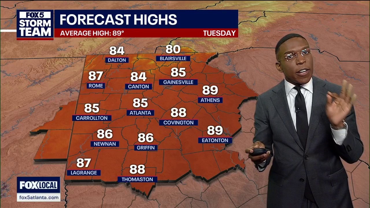
The storm threat is over and temperatures will drop to 85 degrees Tuesday before a major summer warmup brings 90-degree heat over the weekend.
ATLANTA - It looks like the severe storm threat for Monday evening is over, ushering some changes to the forecast, including a warm-up into the weekend.
All watches and warnings from earlier severe weather have been allowed to expire.
Storm threat levels
What we know:
A weakening line of showers and storms is continuing its trek across the state lines into north Georgia tonight. While the atmospheric setup is stabilizing, plenty of ambient moisture remains to trigger localized heavy downpours. No active watches or warnings are currently in effect for the metro area.
Showers linger overnight
What they're saying:
"I'm still tracking a couple complexes that are stretching across East and Middle Tennessee and then even some into north and central Alabama," said FOX 5 Storm Team Meteorologist Jonathan Stacey. "The general trend is for all of that action to really kind of converge on north Georgia as it moves farther to the east."
Forecasters emphasize that while severe weather risks are over for the night, a few loud rumbles of thunder and gusty winds could pop up.
Overnight storm tracks
Timeline:
- Midnight to 2 a.m.: The leading edge of the storm line closes in on the Alabama-Georgia border, pushing heavy downpours from Lake Lanier down through Gwinnett, DeKalb, Coweta, and Fayette counties.
- Pre-dawn to Sunrise: The line continues tracking eastward, steadily losing its intensity and breaking apart.
- Tuesday Morning: Lingering cloud cover will slowly clear out, giving way to bright sunshine by midday.
Behind the weather
Big picture view:
A passing frontal boundary is helping to clear out the stormy weather while temporarily knocking down the summer humidity. This setup will pull down temperatures slightly below normal for this time of year, offering a brief break from typical late-June swelter.
Download the FOX 5 Storm Team app
Regional weather impacts
Local perspective:
Rainfall impacts will be highly sporadic and scattered across metro communities. While structural damage is not expected, isolated locations that sit under heavier downpours could experience brief ponding on roads.
Why you should care:
Even though severe threats have diminished, sporadic storms can still produce sudden gusty winds. Drivers during the early morning hours should watch out for wet roads and sudden drops in visibility during heavy downpours.
Seven-day outlook
By the numbers:
Metro Atlanta 7-Day Forecast:
- Tuesday: High 85 / Morning clouds giving way to plenty of sunshine.
- Wednesday: High 87 / Mostly sunny and highly comfortable.
- Thursday: High 89 / Warm and turning increasingly humid with a 30% chance of rain.
- Friday: High 89 / Typical summer heat with a 20% chance of afternoon storms.
- Saturday: High 91 / Humid and hot with a 20% chance of rain.
- Sunday: High 92 / Blazing sunshine and intense summer warmth.
- Monday: High 93 / High heat indexes continuing into the next workweek.
North Georgia 7-Day Forecast:
- Tuesday: High 81 / Noticeably cooler with clearing morning skies.
- Wednesday: High 83 / Beautifully clear and mild afternoon conditions.
- Thursday: High 85 / Increasing clouds with a small chance for isolated showers.
- Friday: High 86 / Standard seasonal warmth building back in.
- Saturday: High 88 / Humid air returns ahead of the weekend heat spike.
- Sunday: High 89 / Mostly sunny skies across the mountain regions.
- Monday: High 90 / Temperatures touching the 90s to start the week.
Clearing things out
What's next:
Enjoy the comfortable weather through Thursday, because intense summertime heat is ready to jump back into the region. High temperatures will comfortably breach the 90-degree mark starting Saturday and will hold steady well into next week as the humidity surges.
The Source: The information in this story was gathered from the FOX 5 Storm Team.