

Strong storms moving across Georgia state line bring high winds and lightning
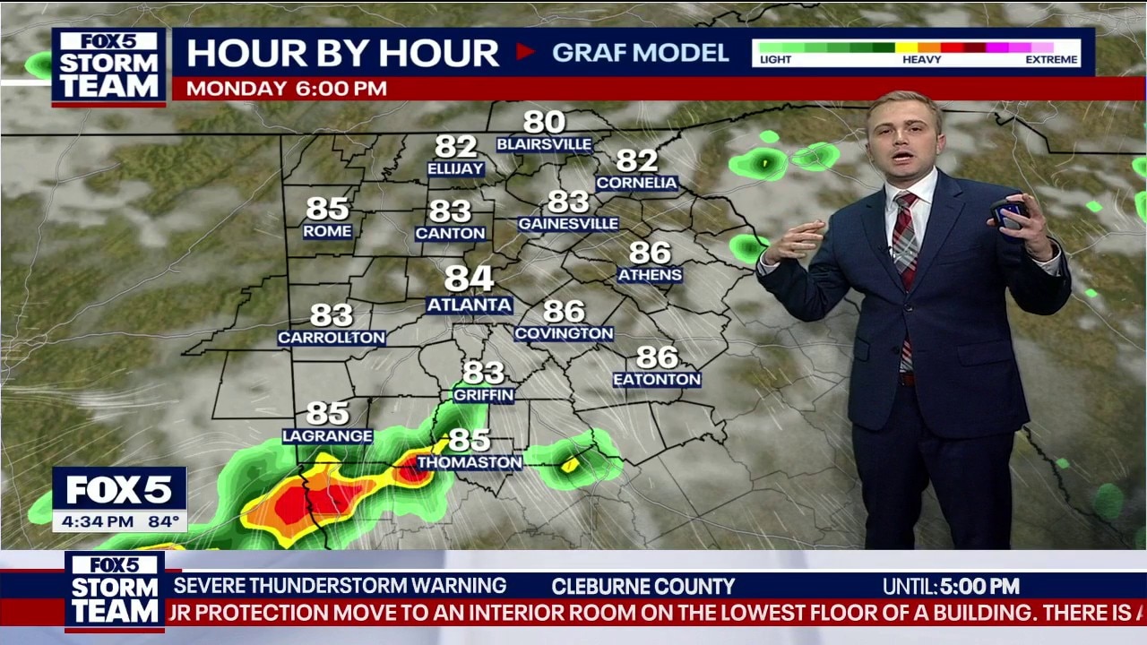
Monday afternoon forecast
The FOX 5 Storm Team track a dangerous severe thunderstorm watch bringing 70 mph winds south of Interstate 20. Families near West Point Lake are urged to get off the water immediately as tracking systems show 513 lightning strikes hitting within 10 minutes. Quiet conditions will return overnight ahead of a clear holiday weekend forecast.
ATLANTA - The FOX 5 Storm Team is tracking a line of severe storms moving across the Georgia state line Monday evening, bringing a risk of high winds, hail, and heavy lightning to areas primarily south of I-20.
Storms move through
What we know:
A severe thunderstorm watch has been officially issued for several counties in the area as a potent line of weather tracking east-southeast at 40 mph slides into the region. The National Weather Service notes that a level 1 out of 5 marginal risk for severe weather is in place, with the primary threat being strong to damaging wind gusts up to 70 mph and isolated hail.
The active severe thunderstorm watch is partial and includes the following counties within the local viewing area:
Carroll, Coweta, Fayette, Haralson, Heard, Lamar, Meriwether, Pike, Spalding, Troup, and Upson.
FOX 5 Storm Team track threats
What they're saying:
"We just got a new severe thunderstorm watch issued basically along and south of I-20 coming right up to I-75," FOX 5 Storm Team Meteorologist Alex Forbes said. "Not only do we have the risk of hail just immediately south of I-20, but this severe thunderstorm warning is now issued for winds up to 70 miles an hour."
Forbes urged anyone spending time outdoors or on local waterways to seek shelter immediately. "If you have any friends out on West Point Lake right now or family members, now is the time to call them and say hey, you’ve got about an hour or so and you need to be off the water because look at the lightning in this thing—513 strikes here within just the last 10 minutes."
Evening storm timing
Timeline:
The severe weather threat will directly impact the western and southern edges of the viewing area through the late afternoon before clearing out later tonight.
- Georgia State Line and Bowdon: Storm impacts begin right around 5 p.m. as the leading edge crosses out of Alabama.
- Heard County and West Point Lake: Heavy rain, strong winds, and frequent lightning will arrive between 5:30 p.m. and 6 p.m.
- Metro Atlanta and South Counties: The bulk of the severe line is expected to push entirely south of the local area between 6 p.m. and 7 p.m., though a few lingering, isolated storms remain possible until 9 p.m. or 10 p.m.
Behind the storms
Big picture view:
The severe storm system is riding along a cold front that is tracking directly into a very warm and humid air mass over the Deep South. As the afternoon heat fuels these storms, they are producing intense microburst-style winds and high-frequency lightning.
Once this front clears the state by Tuesday night, a strong area of high pressure will set up a northeasterly wind flow over Georgia. This shift in the atmosphere will effectively cut off the moisture supply and bring a refreshing, stable air mass down from the north.
Rainfall and wind totals
Local perspective:
The tracking system shows that isolated areas directly under the core of these storms could pick up quick rainfall totals of 1 to 2 inches per hour, leading to minor street flooding. Wind gusts are peaking between 60 and 70 mph near the state line, while lightning data shows over 500 strikes occurring in 10-minute intervals along the strongest leading edges.
Securing the yard
Why you should care:
Winds reaching up to 70 mph are strong enough to knock down tree limbs, compromise weakened power lines, and toss loose outdoor items. Neighbors are encouraged to secure light patio furniture, trash cans, and hanging plants before the gusty front arrives. Boaters on area reservoirs like West Point Lake must get off the water immediately, as high winds and frequent water-to-cloud lightning create extremely hazardous conditions.
The week ahead
By the numbers:
Metro Atlanta 7-Day Forecast:
- Monday: High 82 / Low 65 (Mostly cloudy with evening storms)
- Tuesday: High 80 / Low 60 (Partly sunny, 40% chance of showers)
- Wednesday: High 78 / Low 58 (Sunny and crisp)
- Thursday: High 82 / Low 58 (Bright and beautiful)
- Friday: High 84 / Low 61 (Sunny with a few clouds)
- Saturday: High 85 / Low 65 (Mostly cloudy and comfortable)
- Sunday: High 79 / Low 71 (Partly sunny with low humidity)
North Georgia 7-Day Forecast:
- Monday: High 74 / Low 66 (Storms ending late)
- Tuesday: High 72 / Low 55 (Cooler with a 20% sprinkle chance)
- Wednesday: High 70 / Low 50 (Abundant sunshine)
- Thursday: High 74 / Low 52 (Clear and bright)
- Friday: High 78 / Low 54 (Sunny skies)
- Saturday: High 80 / Low 58 (Increasing weekend clouds)
- Sunday: High 75 / Low 62 (Partly sunny)
Clearing skies ahead
What's next:
The active severe weather threats will wrap up completely before midnight as the initial line of storms slides into southern Georgia. A small 20% to 40% chance of isolated, non-severe showers will linger into Tuesday afternoon. By Wednesday, high pressure takes over completely, ushering in dry air, low humidity, and a stretch of beautiful sunshine just in time for a perfect post-holiday weekend outlook.