

'Unusually severe' Flash Flood Warning in North Georgia | What we know
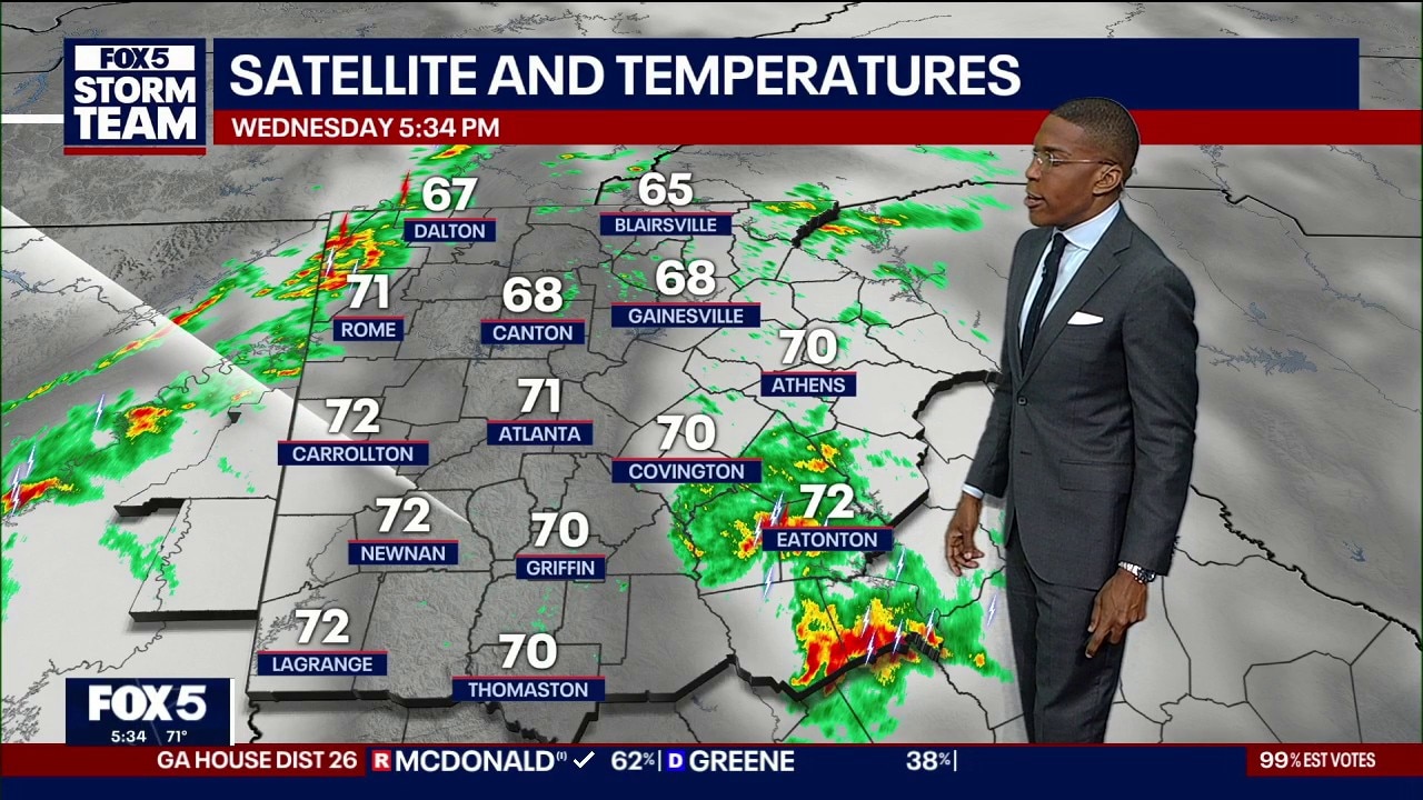
Wednesday evening forecast
A line of severe storms moving across west Georgia toward Interstate 20 and Interstate 85 threatens saturated communities with heavy lightning, downed trees, and isolated tornado rotation before calmer weather arrives Thursday
ATLANTA - Emergency officials placed four North Georgia counties under a flash flood warning late Wednesday evening as a dangerous cold front triggered torrential downpours and scattered severe thunderstorms across the region. Radar-estimated rainfall rates reaching two inches per hour prompted urgent advisories for residents to avoid water-covered mountain roads.
LATEST WEATHER FORECAST & ALERTS
North Georgia flood alerts
What we know:
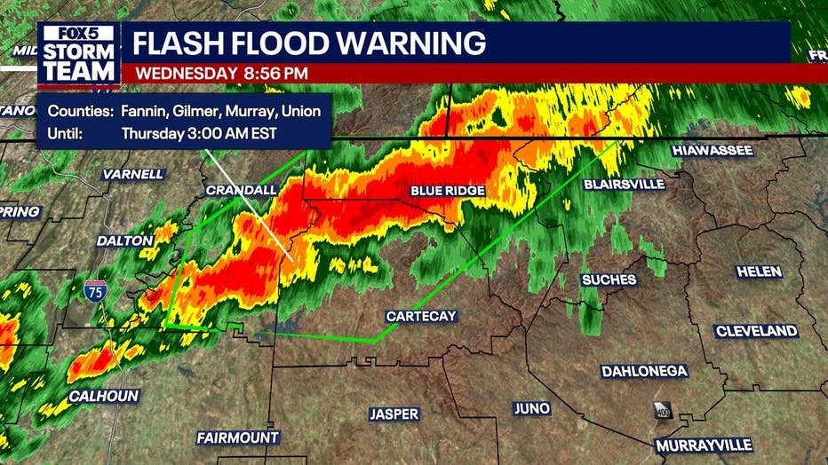
The National Weather Service in Peachtree City issued a flash flood warning at 8:55 p.m. Wednesday that remains in effect until 3 a.m. Thursday. The emergency warning covers Fannin, Gilmer, Murray and northwestern Union counties.
A Considerable Flash Flood Warning was issued for northwestern Fannin County and north central Gilmer County was issued at 9:30 p.m. Between 3 and 4 inches of rain has fallen. Rain is falling at a rate of 1.5 to 2.5 inches per hour. Up to 2 inches of rain is expected. This warning will expire at 12:30 a.m. Thursday unless extended.
Flash flooding hazards threaten small creeks, streams, urban roadways, highway underpasses and low-lying drainage zones. Specific communities facing rapid flooding include Chatsworth, Ellijay, Blue Ridge, Eton, East Ellijay, Morganton, Colwell, Cherry Log, Higdon and Mountaintown.
The weather service also identified Jones Mill, Epworth, Conasauga Lake, Tails Creek, Cohutta Wilderness, Talona, Mineral Bluff, Roundtop, Fort Mountain State Park, Loving, Blue Ridge, Higdon and Colwell as areas at risk. Heavy runoff is expected to create sudden travel hazards across mountain passes.
North Georgia storm damage
What we don't know:
Emergency management officials have not confirmed any structural destruction, washed-out highways or emergency water rescues across the warned North Georgia counties.
Authorities have not determined how many secondary roads may become submerged or blocked by fallen debris overnight.
Wednesday night storm progression
Timeline:
Thunderstorms crossed into western Georgia early Wednesday evening, impacting Dade, Chattooga, Walker, Catoosa and Floyd counties before tracking toward the Interstate 20 corridor. Complex storm cells also developed over Walton and Morgan counties before spreading into Newton County.
Intense lightning surged out of Lake Country across Jasper and Putnam counties, quickly lowering a 72-degree reading in Eatonton. By 7 p.m. Wednesday, the squall line reached the Interstate 575 corridor, bringing heavy rain into Paulding, Douglas and Cobb counties.
Between 8 p.m. and 9 p.m. Wednesday, robust thunderstorms crossed from Cleburne and Randolph counties in Alabama into Carroll County. By 10 p.m. Wednesday, the squall line began breaking apart into spotty but powerful cells along the Interstate 20 and Interstate 85 corridors south and west of Atlanta.
Isolated storm cells will continue to produce heavy downpours in areas like Paulding County through 11 p.m. Wednesday until the front clears the region. Rain chances will decrease overnight as the main frontal boundary pushes eastward.
Georgia severe weather factors
Big picture view:
The National Weather Service placed North and central Georgia under a Level 1 out of 5 severe weather outlook. This marginal designation indicates that while widespread severe storms are unlikely, isolated cells can produce hazardous wind gusts, spin-up tornadoes and localized flash flooding.
Atmospheric instability and a sharp cold front colliding with warm daytime air triggered the stormy conditions. Elevated cloud-to-ground lightning mirrored similar volatile weather patterns that generated flash flooding across Alabama earlier in the day.
Measured rainfall and winds
By the numbers:
Doppler radar recorded expected rainfall rates between 1 and 2 inches in just one hour inside the strongest storm bands. Most locations across northern Georgia had already accumulated a half-inch to an inch of water before the flood alert began.
The Wednesday night forecast lists a 60% chance of precipitation, mainly before 10 p.m., with overnight low temperatures dropping to around 64 degrees under south winds at 5 mph becoming calm. Saturated ground and November root structures mean moderate wind gusts can easily topple trees.
Atlanta seven-day forecast
What's next:
Thursday morning begins with cloud cover and a 20% chance of a lingering shower before clearing skies push afternoon highs up to 76 degrees. Calm morning air will give way to a west wind around 5 mph, with Thursday night turning partly cloudy with a low of 57 degrees.
Friday brings mostly sunny skies and a high near 73 degrees, accompanied by northwest winds between 5 and 10 mph and gusts reaching 15 mph. Clear conditions settle in Friday night as temperatures drop to 50 degrees behind a secondary, dry cold front.
Weekend weather turns sunny and seasonably crisp across North Georgia. Saturday reaches a high near 66 degrees before an overnight low of 42 degrees, while Sunday delivers sunshine with a high near 67 degrees and a low around 42 degrees.
Sunny skies persist into early next week with high temperatures reaching 68 degrees and lows in the 40s on Monday and Tuesday. Mostly sunny weather and an afternoon high near 68 degrees are expected for Veterans Day.
Flooded roadway safety tips
What you can do:
The National Weather Service urges all motorists to turn around and avoid driving through water across roadways. Most flood fatalities take place inside vehicles, and identifying road washouts becomes significantly harder in the dark.
Travelers should keep mobile devices charged to receive instant weather updates if flash flooding occurs near their route.