

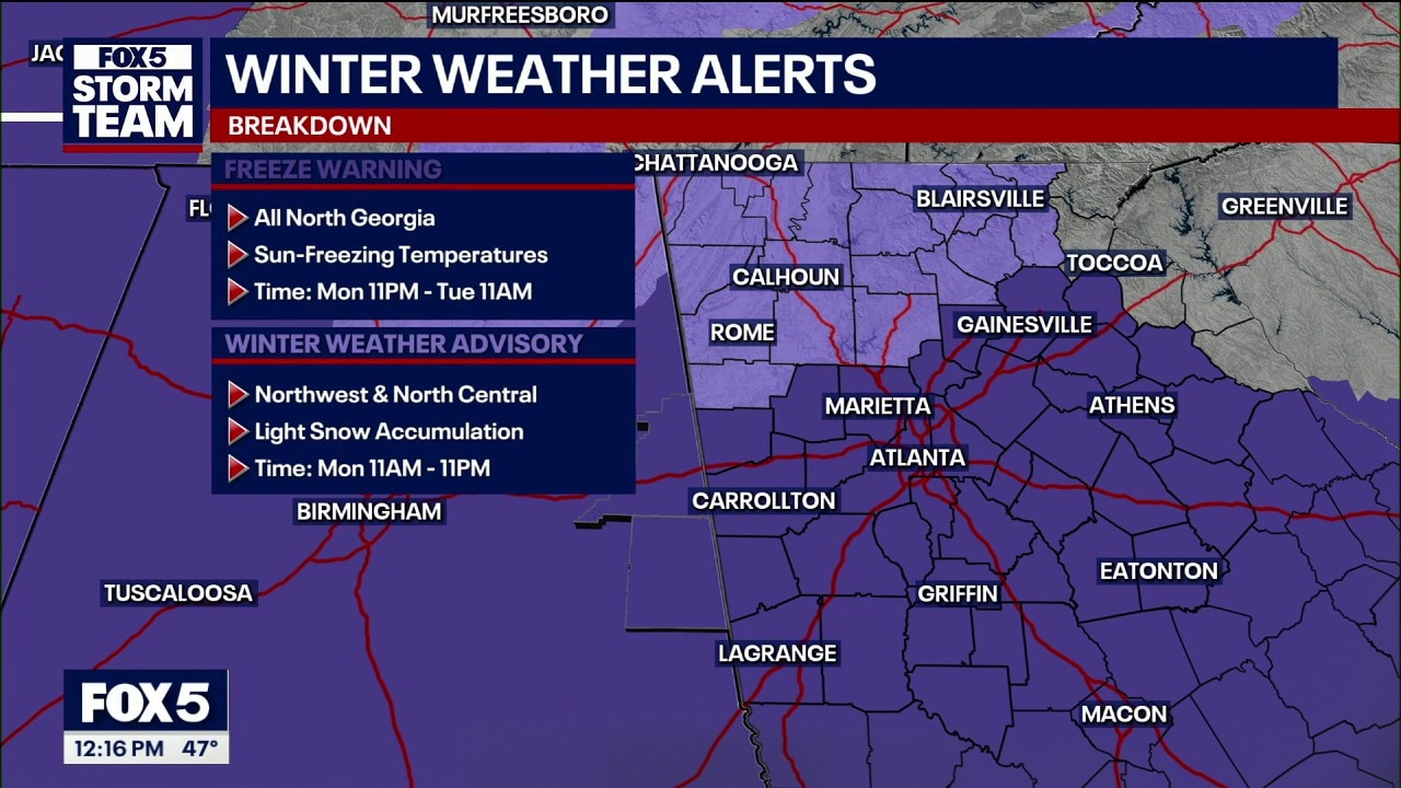
Winter weather advisory issued for multiple North Georgia counties
Monday noon weather forecast
Today's weather is a drastic change from last week. After early morning storms, the temps are dropping dramatically and there's a chance of snow in some parts of North Georgia this afternoon.
ATLANTA - Residents are facing a day of dramatic atmospheric whiplash as a powerful storm system exits the region, making way for an unseasonable plunge into winter-like conditions.
What we know:
The severe weather that swept through Georgia early Monday morning prompted numerous severe thunderstorm and tornado warnings across the state. While the threat of severe storms has now passed for the metro Atlanta area, the FOX 5 Atlanta Storm Team is tracking a brand-new tornado watch shifting eastward into Southeast Georgia and the Carolinas. Reports of downed trees have already surfaced across several counties following the line's passage.
The real "shock" follows immediately behind the cold front. Despite starting the morning at 66 degrees, temperatures are expected to crash into the low 40s by late afternoon—the time of day typically reserved for peak warmth. Gusty winds of 20 to 25 mph will add a significant bite to the air, potentially bringing wind chill values into the 30s before sunset.
A Winter Weather Advisory has been issued for multiple counties in North Georgia, including Cherokee, Bartow, Floyd, Polk, Dawson, Pickens, Gordon, Chattooga, Dade, Walker, Catoosa, Whitfield, Murray, Gilmer, Fannin, Union, Towns, Lumpkin, and White. It is possible that there many be enough snow to accumulate briefly on grass and elevated surfaces. However, road temps should prevent in serious trouble for drivers.
The FOX 5 Storm Team is also monitoring the potential for light snow showers or flurries to develop in North Georgia by Monday afternoon. While the warm ground is expected to prevent significant accumulation, a light dusting is possible in higher elevations. Looking ahead, a Freeze Warning is set to take effect at 11:00 p.m. tonight, with temperatures expected to drop into the widespread 20s by Tuesday morning.
FOX 5 Atlanta has received reports of damage in multiple areas because of strong winds, including trees down in Woodstock in Cherokee County near the Fulton County line, Sandy Springs in north Fulton County just south of the Chattahoochee River and Carroll County.
Warming centers to open
The City of Atlanta says it will open two of its warming centers tonight and Tuesday night.
The first warming center will open at Central Park Recreation Center at 400 Merritts Ave. NE. The second one will open at Selena S. Butler Park and Recreation Center at 98 William Homes Borders Drive NE. They will be open from 8 p.m. Monday to 11 a.m. Tuesday and 8 p.m. Tuesday to 9 a.m. Wednesday.
Pervious warnings
What they're saying:
The National Weather Service issued a wave of severe thunderstorm warnings for a massive stretch of "real estate," extending from Buchanan up to Acworth and covering significant portions of Carroll, Paulding, and Cobb counties. The FOX 5 Atlanta Storm Teams warned that while the storms are currently rolling eastward, areas not yet seeing rain should prepare for high winds, heavy downpours, and frequent lightning.
SCHOOL CLOSINGS & DELAYS
Of particular concern is the "spin-up" potential within this line of storms. The Storm Team emphasized that a severe thunderstorm warning should be treated with the same level of caution as a tornado warning, noting that the current environment is highly conducive to rapid rotation with little to no lead time. This follows reports of damage earlier this morning in the Dalton area, where a tornado warning was previously in effect.
As the storm line exits toward Athens by mid-morning, a "tremendous shock" awaits behind it. A powerful blast of cold air is expected to replace the morning humidity, dropping afternoon temperatures into the 40s. The shift is so aggressive that moisture on the back end of the system could briefly turn into light snow or flurries in far North Georgia and the north metro suburbs.
Why you should care:
As the front moves through Monday, the FOX 5 Storm Team suggests rainfall will be steady, eventually tapering off to a possible "stray flake" in some areas as the cold air rushes in. No significant accumulation or impact is expected from any wintry mix.

FOX 5 Atlanta graphic
What's next:
After the severe weather threat clears Monday morning, the region will experience a brief but intense "winter chill" for St. Patrick's Day. This cold snap will be short-lived, with a significant warmup expected by the end of the week just in time for the first day of spring.

FOX 5 Atlanta image
The Source: Information in this article came from the FOX 5 Storm Team and the National Weather Service.