Tropical Storm Idalia forecast to become major hurricane before Florida landfall
Tracking Idalia: Stream FOX 35 News below
Tropical Storm Idalia is forecast to become a dangerous category 3 hurricane on its approach to Florida's Gulf Coast before making landfall this week, according to the National Hurricane Center.
PREPARATION HELP: Where to get sandbags in Central Florida ahead of Tropical Storm Idalia's landfall along coast
Live updates below
Monday, Aug. 28
11 a.m. advisory | Storm surge and hurricane warnings have been issued for portions of the west coast of Florida as Idalia makes its journey to Florida.
- A Storm Surge Warning has been issued from Englewood northward to the Ochlockonee River, including Tampa Bay.
- A Hurricane Warning has been issued from the Middle of Longboat Key northward to the Holocene River, including Tampa Bay.
- A Tropical Storm Warning has been issued from Chokoloskee northward to the Middle of Longboat Key, and from west of the Lockheed River westward to Indian Pass.
- A Storm Surge Watch has been issued from Mouth of the St. Mary's River to Altamaha Sound, Georgia. A Tropical Storm Watch has been issued for the Atlantic coast of Florida and Georgia from Sebastian Inlet, Florida northward to Altamaha Sound, Georgia.
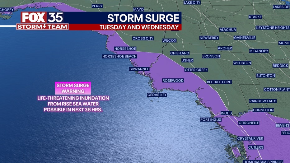
"On the forecast track, the center of Idalia is forecast to pass near or over western Cuba tonight, over the extreme southeastern Gulf of Mexico by early Tuesday, and reach the Gulf coast of Florida on Wednesday," the NHC said.
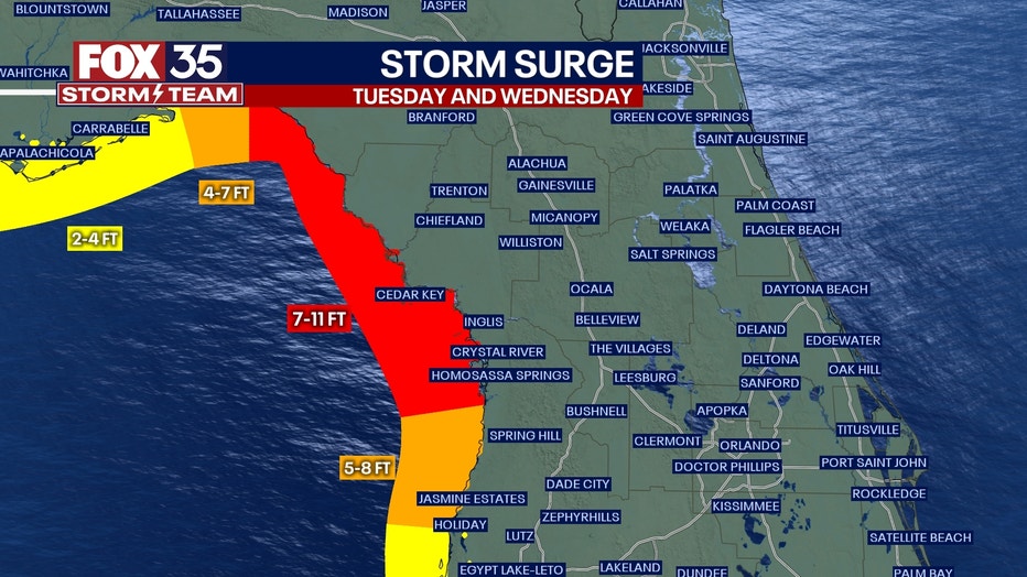
The risk for life-threatening storm surge and dangerous hurricane-force winds continue to increase along portions of the west coast of Florida and the Florida Panhandle beginning as early as late Tuesday.
10:41 a.m. update | Marion County Public Schools will be closed on Tuesday, Aug. 29 and Wednesday. Aug. 30 ahead of Tropical Storm Idalia, officials announced.
Extracurricular activated planned for Monday afternoon have been canceled – except for the Marion afterschool program.
8 a.m. advisory | Tropical Storm Idalia is forecast to become a hurricane when it nears western Cuba later Monday – before it reaches Florida's Gulf Coast.
The risk for life-threatening storm surge and dangerous hurricane-force winds continue to increase along portions of the west coast of Florida and the Florida Panhandle beginning as early as late Tuesday.
Storm surge and hurricane watches are in effect for portions of Florida's west coast and Florida Panhandle coast. Forecasters expect areas of flash and urban flooding across portions of the west coast of Florida, the Florida Panhandle and southern Georgia Tuesday into Wednesday, before spreading into portions of the eastern Carolinas Wednesday into Thursday.
Gov. Ron DeSantis and state emergency management officials are expected to hold a news conference about the storm at 9 a.m. You can live stream the update by clicking here or watching Good Day Orlando in the above video player.
5 a.m. advisory | Tropical Storm Idalia is expected to become a major hurricane before it reaches the Gulf Coast of Florida. Life-threatening storm surge and dangerous winds are becoming increasingly likely for portions of Florida, the NHC said.
New track:
DOWNLOAD FOX 35 NEWS APP AND FOX 35 STORM TEAM WEATHER APPS
Forecasters expect areas of flash and urban flooding across portions of the west coast of Florida, the Florida Panhandle and southern Georgia Tuesday into Wednesday, before spreading into portions of the eastern Carolinas Wednesday into Thursday.
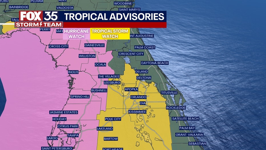
Hurricane watches have been issued for the northwestern coast of Florida. The Tropical Storm Watch has been expanded into Orange, Seminole and Osceola counties.
Sunday, August 27:
11 p.m. advisory | Tropical Storm Idalia continued strengthening late Sunday with maximum sustained winds at 60 mph. The storm's center remained stationary, located about 145 miles from Cuba.
Idalia is expected to pick up motion to the north-northeast on Monday, bringing it over the extreme southeastern Gulf of Mexico by Monday night, where the water is very warm and favorable for further strengthening. Idalia will then continue on a northward or north-northeastward path over the eastern Gulf of Mexico on Tuesday and reach the Florida Coast on Wednesday. Idalia is expected to reach hurricane strength by early Tuesday and could be a Category 2 storm at landfall.
Hurricane Warnings have been issued for portions of Cuba while Tropical Storm Warnings are in effect for the Yucatán Peninsula.
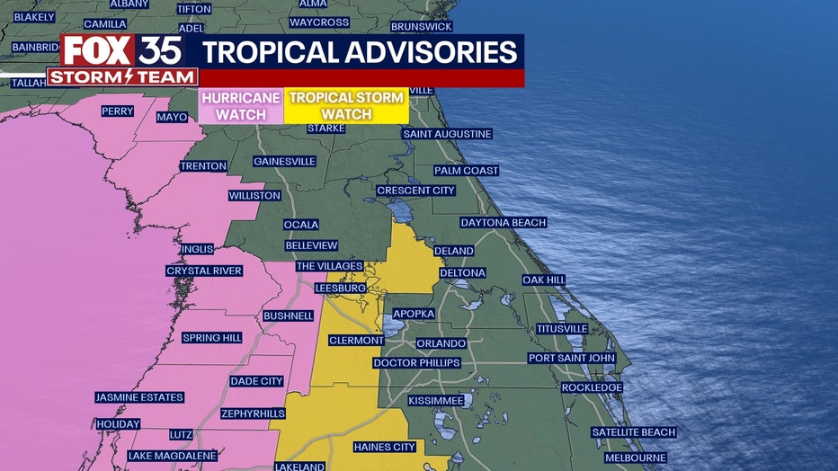
A Storm Surge Watch is in effect for:
- Chokoloskee to Indian Pass Florida, including Tampa Bay
A Hurricane Watch is in effect for:
- Englewood to Indian Pass Florida, including Tampa Bay
A Tropical Storm Watch is in effect for:
- South of Englewood to Chokoloskee Florida
- Lower Florida Keys west of the west end of the Seven Mile Bridge
7 p.m. advisory | Tropical Storm Idalia is "a little stronger," according to the National Hurricane Center. Buoy data shows that Idalia's sustained winds have increased to nearly 45 mph with higher wind gusts.
"Idalia is moving toward the east-northeast near 3 mph (6 km/h). A slow, possibly erratic, motion is expected overnight. A generally northward to north-northeastward motion at an increasing forward speed is expected on Monday and Tuesday. On the forecast track, the center will move over the eastern Gulf of Mexico on Monday and Tuesday, and approach the northeastern Gulf coast late Tuesday."
Idalia is expected to reach hurricane strength by early Tuesday.
All previously issued storm surge, tropical storm, and hurricane watches remain the same as the 5 p.m. advisory.
5 p.m. advisory | Tropical Storm Idalia is forecast to strengthen into a hurricane over the southeastern Gulf of Mexico by early Tuesday. It could strengthen some more as it approaches the northeastern Gulf Coast late Tuesday.
Idalia is currently moving northeast at 3 mph with maximum sustained winds at 40 mph. It's located about 95 miles east-southeast of Cozumel, Mexico.
The storm is expected to make a slow, possibly erratic, motion overnight as it moves generally toward the north or north-northwest at an increasing forward speed.
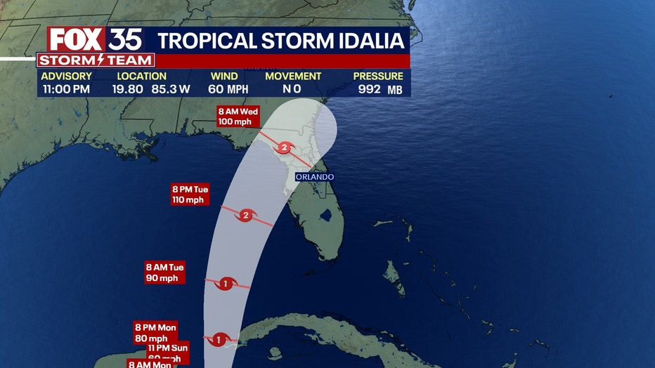
A storm surge watch has been issued for Chokoloskee to Indian Pass, Florida, including Tampa Bay, meaning there is a possibility of life-threatening inundation, from rising water moving inland from the coastline, during the next 48 hours.
A hurricane watch is in effect for Englewood to Indian Pass, Florida, including Tampa Bay, meaning hurricane conditions are possible.
A tropical storm watch is in effect for south of Englewood to Chokoloskee and the Dry Tortugas, meaning tropical storm conditions are expected.
NEW: Could Tropical Storm Idalia impact UCF football’s home opener?
2:45 p.m. | Florida Gov. Ron DeSantis held a press conference about Tropical Storm Idalia on Sunday afternoon.
On Saturday, he declared a State of Emergency for 33 Florida counties "out of an abundance of caution" to allow the Florida Division of Emergency Management to begin staging resources and allow Floridians to begin preparing for a possible storm.
Watch the press conference below.
DeSantis shares Tropical Storm Idalia update
Florida Gov. Ron DeSantis hosted a press conference Sunday about Tropical Storm Idalia and its potential impact on Florida. The press conference comes one day after the governor declared a State of Emergency in 33 Florida counties ahead of the storm's expected landfall.
2 p.m. advisory | Tropical Storm Idalia is bringing heavy rains to parts of western Cuba and the Yucatan Peninsula, according to the National Hurricane Center. Maximum sustained winds are at 40 mph as Idalia moves north at 2 mph.
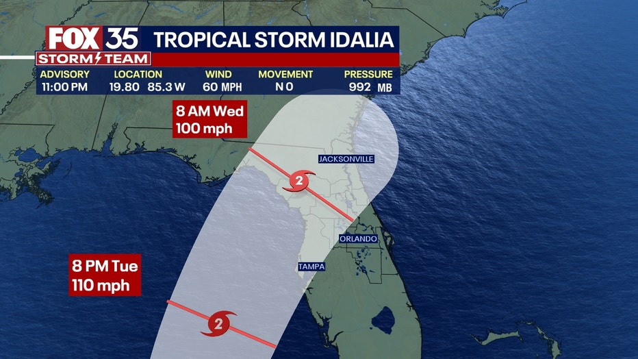
Idalia is located about 80 miles east-southeast of Cozumel, Mexico as of Sunday afternoon, and is expected to move near the Yucatan Channel through Sunday night. The storm is forecast to speed up toward the north on Monday, which would put it near the Gulf of Mexico.
Idalia is expected to become a hurricane by Tuesday, the NHC said.
Parts of Florida, including the west coast and panhandle, are expected to get 3 to 6 inches of rain, and up to 10 inches in other areas. Scattered flash and urban flooding is also possible by Tuesday and into Thursday.
11:15 a.m. advisory | Tropical Depression Ten has strengthened to Tropical Storm Idalia, according to the NOAA Hurricane Hunters. Maximum sustained winds are estimated to be 40 mph.
Here is the latest possible pathway.
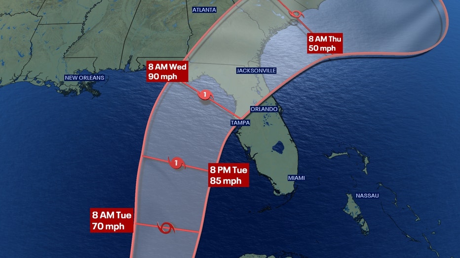
Tropical Storm Idalia is located about 80 miles east-southeast of Cozumel, Mexico, and has sustained winds of 40 mph. It is moving east at 2 mph, the NHC said.
It is expected to become a hurricane over the Gulf of Mexico and presents threats of life-threatening storm surge, flooding, heavy rainfall, and hurricane-force winds along Florida's Gulf and Panhandle as early as Tuesday.
The NHC is recommending that people have their hurricane plan in place.
Storm surge and hurricane watches may be issued for ports of Florida's Gulf Coast later Sunday, the NHC said.
8 a.m. advisory | Meteorologist Ian Cassette goes over the 8 a.m. advisory issued for Tropical Depression Ten, which is expected to become a tropical storm and an eventual hurricane.
Tracking Depression 10: Latest updates from National Hurricane Center
Here is the latest update on Tropical Depression 10, which headed toward the Gulf of Mexico and possibly to Florida early this week. The National Hurricane Center said it was expected to become a tropical storm -- which would be named Tropical Storm Idalia -- on Sunday.
7:57 a.m. | Tropical Depression 10 is nearing tropical storm intensity, the National Hurricane Center says. If it becomes a tropical storm, it will be known as Tropical Storm Idalia.
7:30 a.m. | Tropical Depression 10 is expected to strengthen into Tropical Storm Idalia on Sunday, the National Hurricane Center said.
In its 4 a.m. advisory, the NHC said:
- The tropical system was 30 miles south-southeast of Cozumel, Mexico
- Has maximum sustained winds of 35 mph
- Currently moving south at 5 mph
- Minimum Central Pressure: 1001 mb
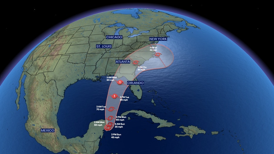
"The depression is moving toward the south near 5 mph (7 km/h), and it is likely to meander near the Yucatan Channel through early Monday. A faster motion toward the north or north-northeast is expected later on Monday, bringing the system over the eastern Gulf of Mexico," the NHC said.
It is likely to become a tropical storm on Sunday, and then a category 1 hurricane by Tuesday, before possibly reaching Florida.
SUMMARY OF WATCHES AND WARNINGS IN EFFECT:
A Tropical Storm Warning
- Yucatan Peninsula from Tulum to Rio Lagartos, including Cozumel
- Pinar del Rio Cuba
A Tropical Storm Watch
- Isle of Youth Cuba
A Tropical Storm Warning means that tropical storm conditions are expected somewhere within the warning area within 36 hours.
A Tropical Storm Watch means that tropical storm conditions are possible within the watch area, generally within 48 hours.
Interests in Florida should monitor the progress of this system.

