

Francine to impact Atlanta's weather through the weekend

Thursday morning weather forecast
As Tropical Storm Francine heads through Mississippi, its effects are going to start being felt in north Georgia with rain and gusty winds.
ATLANTA - Georgia is bracing to feel the effects of Francine as the storm slowly makes it way across Louisiana and Mississippi on Thursday.
The storm made landfall in Terrebonne Parish, Louisiana on Wednesday evening as a category 2 storm and has since been downgraded to a tropical storm.
As of 4 a.m. Eastern, the center of the storm was located about 60 miles north of New Orleans. The storm was packing 45 mph winds and moving northeast at 12 mph.
A Tropical Storm Warning is in effect for Grand Isle, Louisiana to the Alabama/Florida border and metropolitan New Orleans.
Hurricane Francine makes landfall in Louisiana
The storm drew fuel from exceedingly warm Gulf of Mexico waters, rapidly increasing before making landfall. The storm came ashore around 6 p.m. Eastern as a dangerous category 2 storm, knocking out power to more than a quarter million customers and threatening a large stretch of the Gulf Coast with flooding and destructive winds.
Officials reported flooded streets and downed tree limbs Wednesday evening around southern Louisiana, while drenching rains in New Orleans raised fears of flash flooding.
There were no immediate reports of any deaths or injuries.
The National Hurricane Center expects Francine to possibly turn towards the north-northeast and north sometime in the next 24 hours as it keeps decreasing its speed.
Thursday morning, Francine is expected to weaken into a tropical depression and then to a post-tropical cyclone.
Francine to impact Georgia's weather

After making landfall, Francine is expected to continue to trek further inland. While the center of the storm will stay well west of the state, it will still impact Georgia's weather for the next few days.
Wednesday was breezy and mostly cloudy. Those clouds will continue to increase through the evening hours, as will the winds. Some showers and thunderstorms are possible across north Georgia well into the evening on Wednesday as the storm's outer bands push into the Peach State.

The biggest area of concern will be west of Interstate 75, where the threat of an isolated tornado cannot be ruled out through Friday.
The rain threat will extend through Friday evening, possibly impacting some high school football games. Some periods of heavy rain could dump 1 to 2 inches, with some isolated areas seeing more through Sunday.

Winds will increase over the next 24 hours with the worst expected on Thursday evening. Expect winds out of the east at 15 to 25 mph with gusts as high as 35 to 40 mph.
The good news is the temperatures will dip into the mid-70s over the weekend due to the rainy and cloudy conditions.
Wind Advisory for northwest Georgia
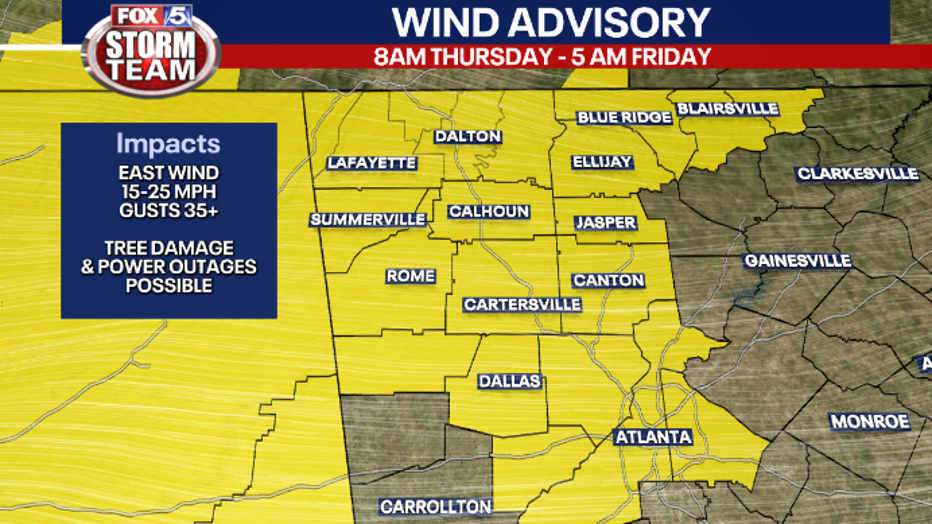
Cobb, DeKalb, Douglas, North and South Fulton, Union, Towns, Paulding, Polk Dade, Walker, Catoosa, Whitfield, Murray, Fannin, Gilmer, Chattooga, Gordon, Pickens, Floyd, Bartow, and Cherokee counties are under a Wind Advisory from 8 a.m. Thursday through 5 a.m. Friday.
Winds will be as high as 25 mph out of the east with gusts as high as 35 mph.
A Flood Watch is in effect for portions of northwest and west central Georgia, including Carroll, Haralson, Chattahoochee, Coweta, Harris, Heard, Marion, Meriwether, Muscogee, Pike, Schley, Stewart, Sumter, Talbot, Taylor, Troup, Upson and Webster counties from 8 a.m. Thursday to Friday evening. This Food Watch may be expanded to include more counties.
Officails estimate rain between 2 and 4 inches through FRiday with possibly 6 inches in some areas.
The Associated Press contributed to this report.