

Be weather aware Friday: Fronts brings severe weather threat to Georgia
Thursday Evening Weather Update
A very nice St. Patrick's Day evening with a mostly clear sky and pleasant temps. Storms are expected on Friday beginning late morning. Heavy rain and damaging winds will be the greatest threats, but there is a low end risk for a tornado. Here is the latest.
ATLANTA - Georgians will want to be weather aware on Friday as another round of storms move through bringing an increased severe weather risk.
A warm front followed by a cold front will be moving in bringing the threat of heavy rains, damaging winds, and a spin-up tornado cannot be ruled out.

What is the timing of Friday's severe weather threat in Georgia on Friday?
The first few rounds of storms could come as early as 10am, but the threat will remain through the evening hours.
Where is the greatest threat of severe weather in Georgia on Friday?
The fronts will impact much of the Deep South with the biggest threat, a Level 3, along the Gulf Coast from Mississippi through Alabama and into the Florida Panhandle.

The highest risk in Georgia is currently in western counties
What threats could this severe weather bring to Georgia on Friday?
The storms could bring one to two inches of rain and as much as three inches in some areas of Georgia. There will be a lot of wind associated with the front with some thunderstorms that could pack damaging winds.
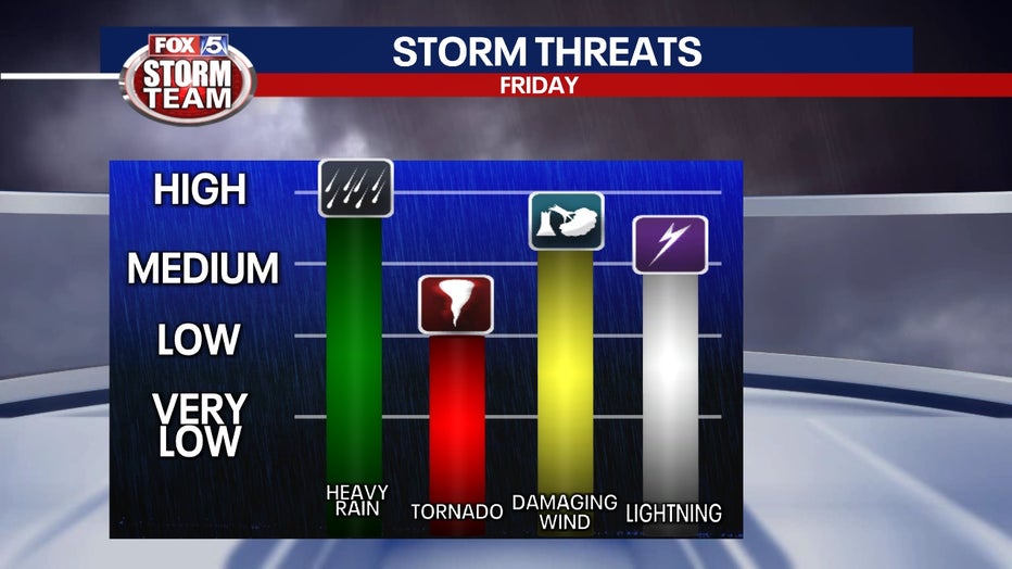
There is sheer in the atmosphere, but not a lot of instability, this is why the risk is lower in Georgia. Still, the potential for a spin-up tornado is not completely ruled out.
What does the rest of the weekend and week ahead look like?
Once the front moves through on Saturday, folks will be walking up to temperatures in the low- to mid-50s. It won’t warm up too much on Saturday with temperatures reaching the mid- to upper-60s.
It will get sunnier as the weekend progresses with Sunday being sunnier and warmer with highs in the low-70s and lows in the mid-40s.
There will be a warming trend through Tuesday when the clouds return and another round of showers and thunderstorms also return on Wednesday.
WATCH: FOX 5 NEWS LIVE COVERAGE
_____