

Fast-moving storm to bring strong winds, heavy rain to North Georgia

ATLANTA - A fast-moving storm system will bring strong to damaging winds, heavy rainfall, and the potential for an isolated tornado to North Georgia.
The timing of this event will be late Tuesday night into Wednesday morning.
Strong wind, heavy rain expected overnight Tuesday into Wednesday
The backstory:
A line of heavier showers and embedded thunderstorms will sweep across the region, bringing the strongest winds and heaviest rain within a narrow window of less than three hours. Given the system’s quick-moving nature, conditions will deteriorate rapidly but improve just as quickly after the storms pass.
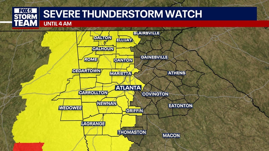
Severe Thunderstorm Watch issued
Big picture view:
A Severe Thunderstorm Watch has been issued for Bartow, Carroll, Catoosa, Chattahoochee, Chattooga, Cherokee, Clayton, Cobb, Coweta, DeKalb, Dade, Douglas, Fannin, Fayette, Floyd, Fulton, Gilmer, Gordon, Haralson, Harris, Heard, Marion, Meriwether, Murray, Muscogee, Paulding, Pickens, Pike, Polk, Spalding, Stewart, Talbot, Troup, Walker, Webster, and Whitfield counties until 4 a.m. on Wednesday.
High Wind Warning in North Georgia
What we know:
A High Wind Warning is in effect for Dade, Walker, Catoosa, Whitfield, Murray, Fannin, Gilmer, Union, Towns, Gordon, Pickens, Dawson, Lumpkin, and White counties from 7 p.m. on Tuesday until 7 a.m. on Wednesday.
Southeast winds between 15 and 20 mph with gusts of 30 to 40 mph are possible this evening.
Overnight, the winds will shift south at 20 to 30 mph with gusts of up to 55 mph expected.
Winds will die down a bit on Wednesday. Expect southwest winds of 15 to 25 mph with gusts of 35 to 45 mph.
Further south, a Wind Advisory will remain in place from 7 a.m. to 7 p.m. on Wednesday.
A Wind Advisory will be in effect for Chattooga, Floyd, Bartow, Cherokee, Forsyth, Hall, Banks, Jackson, Madison, Polk, Paulding, Cobb, North Fulton, Gwinnett, Barrow, Clarke, Oconee, Oglethorpe, Wilkes, Haralson, Carroll, Douglas, South Fulton, DeKalb, Rockdale, Walton, Newton, Morgan, Greene, Taliaferro, Heard, Coweta, Fayette, Clayton, Spalding, Henry, Butts, Jasper, Putnam, Hancock, Warren, Troup, Meriwether, Pike, Upson, Lamar, Monroe, Jones, Baldwin, Washington, Glascock, Jefferson, Harris, Talbot, Taylor, Crawford, Bibb, Twiggs, Wilkinson, Johnson, Emanuel, Muscogee, Chattahoochee, Marion, Schley, Macon, Peach, Houston, Bleckley, Laurens, Treutlen, Stewart, Webster, Sumter, Dooly, Crisp, Pulaski, Wilcox, Dodge, Telfair, Wheeler, Montgomery, and Toombs counties through 7 p.m. on Wednesday.
Winds are expected to be out of the south 15 to 25 mph, with gusts of 35 to 45 mph.
Damaging winds will blow down trees and power lines, causing numerous power outages and making travel difficult for high-profile vehicles. Gusty winds will also blow around unsecured objects. People are urged to secure loose objects that could be blown around or damaged by the wind. Such strong winds can make driving difficult, especially for high-profile vehicles.
North Georgia forecast
Timeline:
- When: Storms will move in from west to east between 10 p.m. Tuesday and 10 a.m. Wednesday
- Where: All of north and central Georgia will be affected
What's next:
- Strong to damaging wind gusts exceeding 60 mph
- Brief tornado possible
- Gusty winds ahead of the storms (beginning Tuesday afternoon in western Georgia)
- Falling trees & power outages possible
The Source: This article contains an original forecast from the FOX 5 Storm Team.