

State of Emergency canceled for DeKalb County | The latest forecast

Thursday midday weather forecast
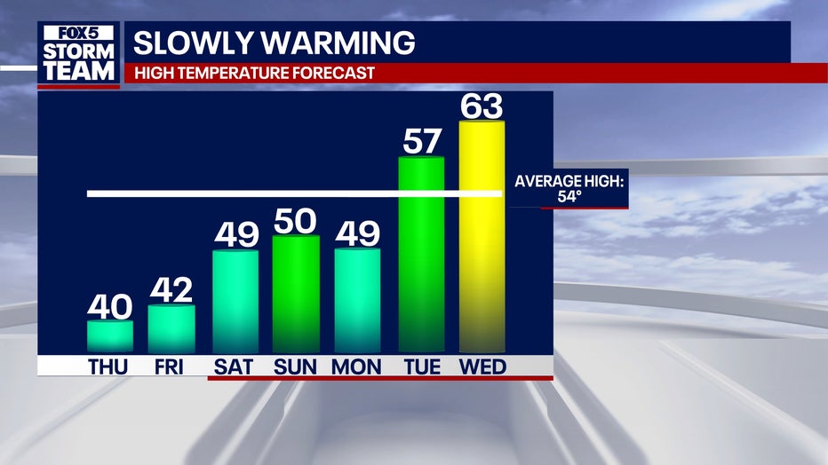
Expect rain to be likely Monday with temperatures to become much milder next week.
ATLANTA - The State of Emergency was canceled in DeKalb County shortly before 3 p.m. Thursday although Gov. Kemp's order remains in effect for the state of Georgia.
However, DeKalb County CEO Lorraine Cochran-Johnson is urging drivers to still use caution during the evening hours because remaining water could refreeze and make roads slick. The decision to cancel the State of Emergency was made after road conditions improved significantly, and emergency crews addressed critical safety concerns across the county.
Atlanta to warm up Thursday
What we know:
Georgia residents have experienced a bitterly cold stretch over the past several days, but relief is on the horizon, according to FOX 5 Storm Team meteorologist Johnathan Stacey.
"A slow gradient to warmer temperatures is on the way," Stacey said. "We’re not going to get there anytime fast, but we’re moving in the right direction."

Atlanta Mayor Andre Dickens said crews worked all day on Wednesday to clear roads and take care of emergencies. Crews are now salting back roads to get them ready for drivers on Thursday.
Timeline:
The recent cold spell hit its peak early Thursday morning with a low of 14 degrees in Atlanta, marking the coldest temperature recorded since Jan. 21, 2024. The state endured 66 consecutive hours of below-freezing temperatures, beginning Sunday evening.
"Yesterday’s snowfall total at Hartsfield-Jackson International Airport measured 1.1 inches," Stacey said. "That brings the season total to just over one inch."
By Thursday afternoon, temperatures had climbed to 35 degrees in Atlanta, with similar conditions across much of North Georgia. However, wind chills continued to make it feel colder in higher elevations. For example, Blue Ridge experienced a wind chill of 32 degrees, while it felt like 33 degrees in areas such as Rome and Evans.
"Things have really settled with plenty of sunshine helping us out," Stacey said. "I hope you savor it because it doesn’t stick around long."
A new weather system is expected to move in Friday morning, bringing increased cloud cover. While Stacey doesn’t anticipate significant precipitation, he noted the possibility of a stray flurry or raindrop in some areas. Temperatures on Friday will struggle to reach the 40s, with highs of 40 degrees expected in Atlanta and Canton, and slightly warmer conditions in Rome, where the forecast predicts a high of 43 degrees. Mountain communities will remain in the 30s.
"We’re making progress," Stacey said. "It’s slow, but we’re working toward our average high for this time of year, which is 54 degrees."

What's next:
Looking ahead, the FOX 5 Storm Team predicts a weekend of sunshine, followed by increased rain chances on Monday, with a 40-50% likelihood of showers. After that, temperatures are expected to rebound significantly.
"By next Wednesday, we’re forecasting a high of 63 degrees," Stacey said. "I, for one, welcome that warm-up. Let’s hope it holds up."
RELATED:
- LIVE: Georgia schools closing Thursday due to winter storm | Full list
- Tuesday’s winter storm results in record snowfall in Atlanta, surrounding areas
- Georgia church services, bible study canceled due to inclement weather
- Stranded and out of gas, Henry County mother and her children stuck on I-75 during snow storm
- Black ice concerns loom as Atlanta’s southside comes back from winter storm
- Treacherous conditions in Snellville improving, drivers need to move stranded vehicles soon
- Drivers in DeKalb County forced to spend night in cars at gas stations
- Georgia icy road closures, snow-related crashes
- Atlanta airport conditions | Travelers face long lines, flight cancelations in wake of winter storm
- Savannah airport sees remaining flights canceled on Wednesday
MARTA service resumes in Atlanta
MARTA has resumed rail service with 20-minute frequency on all lines. The Red Line will run from North Springs to Airport Station. Officials say they will increase service as weather conditions improve.
Bus service will begin at 1 p.m. on routes 6, 19, 40, 78, 107, 110, 111, 123, 185, and 196. Officials say these routes are Phase 1 of their plan to resume service.
Streetcar service will begin operating at 8:15 a.m. on a normal schedule.
Mobility services will begin at noon with the first pick-up at 1 p.m. This service will be restricted to medical trips only.
Are roads still icy?

State of Emergency continues for DeKalb County
DeKalb County remains under a state of emergency due to dangerous roads that could lead to travel troubles on Thursday morning.
What we know:
Slick and dangerous road conditions are expected to persist across much of metro Atlanta and Central Georgia.
Hall, Banks, Jackson, Madison, Fulton, Gwinnett, Barrow, Clarke, Oconee, Oglethorpe, Wilkes, DeKalb, Rockdale, Walton, Newton, Morgan, Greene, Taliaferro, Heard, Coweta, Fayette, Clayton, Spalding, Henry, Butts, Jasper, Putnam, Hancock, Warren, Troup, Meriwether, Pike, Upson, Lamar, Monroe, Jones, Baldwin, Washington, Glascock, Jefferson, Harris, Talbot, Taylor, Crawford, Bibb, Twiggs, Wilkinson, Johnson, Emanuel, Muscogee, Chattahoochee, Marion, Schley, Macon, Peach, Houston, Bleckley, Laurens, Treutlen, Stewart, Webster, Sumter, Dooly, Crisp, Pulaski, Wilcox, Dodge, Telfair, Wheeler, Montgomery, and Toombs counties have the biggest threat of black ice overnight.
Timeline:
Temperatures will rise above freezing around midday on Thursday and should remain above freezing through about 8 p.m., offering some relief.
Officials are encouraging drivers to avoid any unnecessary trips after 6 p.m.
The temps then drop to the mid to upper 20s overnight into Friday morning.
What you can do:
Drivers should be aware of shady areas on roadways, especially on secondary roadways and side streets. Hilly terrain and north-facing slopes also will have an increased chance of ice. While the sun came out on Wednesday, cloud cover on Thursday morning will prevent more of the icy patches from melting.
How long does it take ice to melt on roads?
Dig deeper:
There are multiple factors as to when ice will melt from a roadway. Those include:
Temperature: If the air temperature is above freezing, ice will start melting naturally. The higher the temperature, the faster it melts.
Sunshine: Direct sunlight speeds up melting as it raises the surface temperature.
Salt or deicer usage: Salt or chemical deicer can lower the freezing point of water and speed up the melting process. Depending on the amount applied, ice can melt within minutes to hours.
Traffic and friction: Traffic generates friction and heat, helping to break up ice and speed melting on busy roads.
Thickness of the ice: Thin ice melts faster than thick layers. A thin glaze may disappear in less than an hour, while thick sheets can take several hours or even days without intervention.
Road material: Darker asphalt absorbs heat more efficiently than concrete, helping to melt ice faster when exposed to sunlight.
Humidity: Drier air helps to evaporate melted ice and prevents it from refreezing.
If temperatures remain below freezing and no deicer is used, ice can persist for days or weeks.
When does black ice form?
What we know:
Black ice forms when the air temperature is at or below freezing. It often forms even if the daytime temperature is above freezing, as surfaces cool faster than the air, especially overnight.
Black ice is common in shaded areas, such as under bridges, overpasses, or on tree-lined roads, as these spots stay cooler and receive less sunlight.
It’s nearly invisible because it forms as a very thin, transparent layer, allowing the dark color of the road to show through. This makes it extremely dangerous for drivers and pedestrians.
When will the snow melt?
What we know:
Just like ice, snow begins to melt when temperatures rise above freezing, when it is in direct sunlight, and depends on the thickness of the snow blanket. Snow on paved or concrete surfaces melts faster because these materials retain and radiate heat.
Light snow of between 1–2 inches can melt in a day or less under sunny, above-freezing conditions.
How to drive on icy roads?
Dig deeper:
Officials are warning to avoid unnecessary travel overnight. For those who absolutely need to be on the roads, should make sure to be extra cautious and follow these tips:
Slow down: Reduce your speed significantly. Driving slower gives you more control and reduces the risk of skidding.
Increase the following distance: Leave at least 5 to 6 seconds or more of distance between your car and the vehicle in front of you. This allows extra time to react in case of sudden stops or skids.
Avoid sudden movements: Make gradual and smooth adjustments to your speed, steering, and braking. Sudden actions can cause your tires to lose traction on the ice.
Use low gears: Drive in low gear to increase traction, especially on downhill stretches.
Brake gently: Apply the brakes gently to avoid locking them up. If your car has anti-lock brakes (ABS), press the brake pedal firmly and hold it down and don’t pump the brakes in ABS mode.
Steer into skids: If you have front-wheel drive, take your foot off the accelerator and gently steer in the direction you want the front of the car to go. Those with rear-wheel drive should turn the steering wheel in the direction the rear of your car is sliding while easing off the accelerator. Consult your owner’s manual to see which type you have.
Avoid using cruise control: Cruise control can cause your car to accelerate unexpectedly on slippery surfaces, reducing your ability to control the vehicle.
Be cautious on bridges and overpasses: These areas freeze faster than other parts of the road because they are exposed to cold air above and below.
Use winter tires: Winter tires provide a better grip on icy roads.
Stay alert: Watch for patches of black ice, especially in shaded areas, near water, or under bridges. It can be nearly invisible and very slippery.
Keep emergency supplies: Carry a winter emergency kit that includes blankets, flashlight, ice scraper, sand, salt, or kitty litter for traction, snacks and water, and jumper cables.
Plan ahead: Check the weather and road conditions before heading out. If conditions are severe, avoid driving unless absolutely necessary.
The best way to stay safe is to drive slowly, stay alert, and remain calm in difficult situations. If conditions worsen, it’s better to pull over safely and wait for improvement.
Does 4-wheel drive help on ice?
What we know:
A 4-wheel drive (4WD) system can be helpful in certain icy conditions, but it has its limitations and is not a cure-all for driving on ice. It can improve traction during acceleration, help in light off-road conditions, and reduce the likelihood of getting stuck. However, it does not improve braking, cannot fully prevent sliding or skidding, and can make drivers overconfident when they need to exercise caution.
Tire type is also critical, with the use of a good tread or winter tires being key to maximizing grip.
What we don't know:
Drivers of 4WD vehicles should practice the above tips for driving on snow and ice.4WD can help in certain icy conditions, but it is not a substitute for safe driving techniques, good tires, and an understanding of road conditions. All-wheel drive (AWD) can also provide similar benefits, but like 4WD, it’s not foolproof on ice.
At what temperature does ice melt?
By the numbers:
Water freezes at 32°F or 0°C. If roadways were treated with rock salt (sodium chloride), freezing can occur at 15°F or -9°C. Calcium chloride can lower the freezing point to -25°F or -32°C.
The Source: This article contains an original forecast from the FOX 5 Storm Team. It also contains information from previous FOX 5 Atlanta reports concerning winter weather. This article has been updated since it was originally published to provide new details.