

Severe Thunderstorm Watch in North Georgia; hail, wind, and rain threat continues
ATLANTA - A new wave of strong thunderstorms is forecast to move across metro Atlanta Thursday night, prompting concerns about potential impacts to evening events, including the Atlanta Braves game, and disruptions for overnight travelers and early Friday commuters.
Those storms will spread southeast into the Atlanta metro and central Georgia into the evening hours, bringing a risk of severe weather overnight.
Timeline:
Forecasters say the window for severe storms stretches until 2 a.m. Friday, with the highest risk through 10 p.m.
What we know:
The primary threats include damaging wind gusts and large hail, though isolated tornadoes cannot be ruled out.
What they're saying:
FOX 5 Storm Team meteorologist Jonathan Stacey warned viewers not to underestimate the cellular storms forming on radar. "I want to track these cells here. I know they may seem small, very cellular on the board. However, do not sleep on them because these are going to be the cells that we'll be watching arriving in the Atlanta metro area," Stacey said during the evening forecast.
Stacey noted that the model guidance continues to shift, but as of now, storm activity is expected to approach metro Atlanta around 9 to 10 p.m. "That’s why I’m concerned about the Braves game," he added, referencing potential hazards along I-75 near the Cobb Cloverleaf, as well as DeKalb and Gwinnett counties.
These storms could bring bursts of heavy rain, lightning, and possibly hail. "Some of those rents [on radar] popping up, indicating the heavy downpours, thunder and lightning. Also, hail embedded within those storms," Stacey said.
While the storm's intensity is expected to diminish after midnight in the Atlanta area, eastern Georgia could still face strong conditions deep into the night. "Some communities, especially far east from Madison to Eatonton all the way down to I-16 and Macon, you may just be getting the first round of really strong activity as you're in the middle of the night’s rest," Stacey said. "You could easily be woken up by the rumbles of thunder."
Stacey said the storms should move out in time for the Friday morning commute, though some lingering showers may follow. "Friday is not exactly dry... there is another opportunity that we can get another round of showers, but of the non-severe variety," he said.
As for hail threats, Stacey pointed to areas north of metro Atlanta, while also tracking potential activity flaring up in Coweta County around 8 p.m. "It looks like there's a hail core that just blows up over here in Coweta counties," he said.
Though the immediate concern is the overnight storms, Stacey offered a bit of optimism for the days ahead. "There are sunnier days ahead. But first, a cool down for the weekend."
Dig deeper:
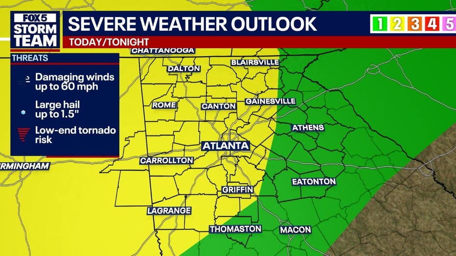
A Severe Thunderstorm Watch is in effect for much of north and central Georgia through midnight Thursday, as the region braces for damaging winds and large hail.
Forecasters say wind gusts up to 60 mph and hail as large as golf balls are possible as a strong front sweeps across the state Thursday evening.
The primary hazards include:
- Damaging wind gusts over 60 mph
- Large hail from 1 to 1.5 inches in diameter (quarter- to near golf ball-size)
- Frequent lightning
- Heavy downpours, especially north of I-20
Residents across Georgia are advised to monitor forecasts, have weather alerts enabled, and prepare for the potential of damaging conditions from Thursday evening into early Friday.
KEEP UP WITH THE LATEST BY DOWNLOADING THE FREE FOX 5 STORM TEAM APP AND FOLLOWING @FOX5STORMTEAM ON X, FORMERLY TWITTER
What's next:
Looking ahead to Friday, isolated thunderstorms are expected during the afternoon hours. A few of these storms may become strong, producing pea to penny-sized hail between 2 p.m. and 8 p.m.
After the storms move out, a brief period of colder weather is expected. Frost and freeze conditions could develop across northeast Georgia on Friday night and may expand to areas north of Interstate 85 by Saturday night.
Metro Atlanta Forecast:
- Friday: Mostly sunny with a 30% chance of afternoon storms. High near 65°F. Winds from the northwest at 10–15 mph, gusting to 25 mph.
- Friday Night: A chance of evening storms before clearing. Low around 44°F.
- Saturday: Sunny and breezy with a high near 64°F. Low around 42°F.
- Sunday: Sunny with a high of 72°F.
- Monday: Warmer conditions return with highs near 82°F.
Northwest Georgia Forecast:
- Friday: 30% chance of storms after 2 p.m. High near 62°F.
- Friday Night: A few early showers, then clearing. Low around 40°F.
- Saturday: Sunny with a high of 62°F. Low near 37°F.
- Sunday and Monday: Sunny with highs in the upper 60s to upper 70s.
Extreme North Georgia Mountains:
- Friday: Chance of afternoon storms with a high near 57°F. Gusts up to 20 mph.
- Friday Night: Low drops to around 36°F.
- Saturday Night: Temperatures may dip to near freezing at 31°F.
- Sunday to Thursday: Mostly sunny with highs gradually warming to around 70°F.
The Source: This article includes an original forecast from the FOX 5 Storm Team and the National Weather Service. This article has been updated since it was originally published.