

LIVE UPDATES | Snow wrapping up in North Georgia counties

Wednesday morning weather forecast
Snow is starting to fall in some parts of North Georgia. Some areas could see about 1/2 inch of accumulation, but major issues are not expected.
ATLANTA - North and central Georgia are bracing for a brief encounter with winter weather.
Snow showers are expected to develop across far North Georgia very early Wednesday morning.
CHECK OUR SCHOOL CLOSURES LIST
SEE OUR LIST OF OPEN WARMING CENTERS
Accumulations are anticipated to be minimal, with totals likely limited to half an inch or less before sunrise.

11:30 A.M.
According to National Weather Service Atlanta, snow is beginning to come to an end across portions of North Georgia.
9 A.M.
Here's the latest weather report from Dalton and Blairsville in North Georgia. The snow has moved out of Dalton and is coming to an end in Blairsville. Snow is still being reported in Blue Ridge.

9AM snow report from North Georgia
FOX 5 Atlanta's Marc Teichner and Brooke Zauner give updates on the weather conditions in Dalton and Blairsville in North Georgia.
8:12 A.M.
NWS Atlanta posts about the expansion of the Winter Weather Advisory to include Bartow, Cherokee, Haralson and Paulding counties out of an abundance of caution.
NWS Atlanta says that the area is dry enough to support decreasing temperatures (via evaporation) as rain continues, which could in turn support light snow later this morning.
7:30 A.M.
Snow is still falling Blairsville, but temperatures are above freezing at this time.
Snow also started around 6:30 a.m. in Blue Ridge and snow could be seen alongside Interstate 75SB near Willowdale Road on a traffic cam. Here's a look at conditions shortly before 7:30.
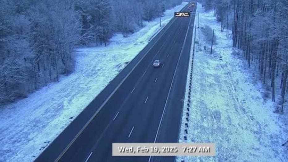
A traffic cam in Rocky Face around the same time also shows snow on the ground near I-75.

And here's a look at a Ringgold traffic cam at 7:28 a.m.
7:23 A.M.
"NWGA Storm Dawg" is also reporting snow on Highway 337 in Chattooga County.
7:20 A.M.
Snow reported at the Butternut Creek Golf Course in Blairsville by "Weather Nerd."
7:10 A.M.
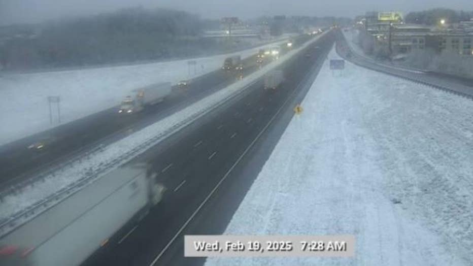
Snow is starting to stick to roads in far northwest Georgia.
Check out the snow-covered cars and grass in Catoosa County.
7 A.M.
It's basically stopped snowing in Dalton (Marc Teichner), but now it is snowing in Blairsville (Brooke Zauner).

Snow falling in Blairsville at 7AM
Snow was falling at 7 a.m. Wednesday in Blairsville. Brooke Zauner reporting live.
6:47 A.M.
Paulding, Haralson and Cherokee counties have just been added to the Winter Weather Advisory.
6:30 A.M.
It's really coming down now in Dalton. Check out the snow on Marc Teichner!
FOX 5 Atlanta has received reports that snow is now falling in Rome.
Rome netcam
6:10 A.M.
The National Weather Service is reporting "big snowflakes" in Dade County and says the snow is starting to stick on grassy surfaces. They are also warning of possible slick spots on bridges and overpasses.
6 A.M.
Snow began falling in parts of North Georgia, including Dalton (Whitfield County) where FOX 5 Atlanta reporter Marc Teichner was stationed.
However, no snow has been reported yet in Blairsville (Union County), which is where FOX 5 Atlanta reporter Brooke Zauner is reporting from this morning.

Light snow falling in Dalton
During the 6AM live report on Wednesday, there was light snow falling in Dalton.
5 A.M.
FOX 5 Atlanta's Marc Teichner is in Whitfield County this morning and Brooke Zauner is in Union County. As of 5 a.m., neither reporter has seen snow in their area.

Wintry weather in Dalton/Blairsville -- 5AM
Wintry weather is back in North Georgia today. Snow is expected in some parts of North Georgia. Here's a look at the conditions at 5AM Wednesday in Dalton and Blairsville.
Winter Weather Advisory in North Georgia
What we know:
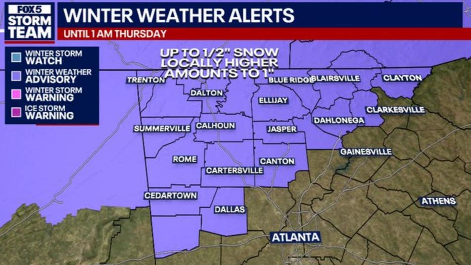
A Winter Weather Advisory was previously issued for Dade, Walker, Catoosa, Whitfield, Murray, Fannin, Gilmer, Union, Towns, Chattooga, Gordon, Pickens, Dawson, Lumpkin, White, and Floyd counties from 1 a.m. on Wednesday to 1 a.m. on Thursday.
Bartow and Polk counties was added to the above list early Wednesday morning.
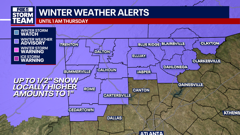
About half an inch is expected in this area, with some areas receiving up to an inch above 2,500 feet.
This is expected to impact road conditions during Wednesday morning and evening commutes.
Will it snow in Atlanta?
Timeline:
Snow showers are expected to develop across far North Georgia very early Wednesday morning.
Accumulations are anticipated to be minimal, with totals likely limited to half an inch or less before sunrise.
FOX 5 Storm Team meteorologist Johnathan Stacey noted, "This will be a bit of kind of half-hearted interaction with winter as we go through the next 24-hour period. Not looking at an all out winter event as we had at least a couple times in."
There is the potential for a light rain and snow mix on Wednesday. Accumulations are expected to occur primarily before noon, with patchy snow showers possibly continuing into the evening. Areas below 2,500 feet may see up to half an inch of snow, while localized amounts near one inch are possible above 2,500 feet. Slick roadways could impact travel, especially during Wednesday morning's commute.
Stacey explained, "Temperatures will take a nosedive, but with us warming up into the 50s today, it's going to be really difficult to bring the temperature down to or below freezing over the next 20 hours or so. So it's likely that most of us will end up with just a squibble squabble."
The forecast indicates that widespread light precipitation will begin to spread from the south and west late Tuesday night into early Wednesday morning. The main precipitation types will be snow and rain, with elevations above 2,000 feet having the best chances for accumulating snow. Areas further south are expected to experience rain as the system moves through.
"Snow amounts are going to be very minuscule. They could pose some issues to travel, however. It looks like it's going to be just kind of a quick run in with winter, with most locations. If getting anything at all, you're going to get less than 1/2 an inch of snowfall, and that's even in the higher elevations," Stacey added.
Colder air moves into Atlanta
What's next:
Following the winter weather, much colder air will move in on Wednesday night, with wind chill values dropping to the single digits above zero to lower teens on Thursday and Friday mornings. Highs on Thursday are expected to be in the 30s across much of north Georgia, with the mountains not getting out of the 20s.
The outlook for the remainder of the week and into the weekend is for generally dry conditions, with temperatures rebounding. The potential for a surface low over the Gulf this weekend could bring rainfall to portions of central Georgia, though the forecast remains uncertain.
As Stacey concluded, "It's really the only day I'm pinpointing really. Over the next five to six days for some problematic weather."

Wintry mix possible in Atlanta
Timeline:
A mix of rain and snow showers is expected to impact Atlanta and extreme north Georgia on Wednesday, with varying weather conditions forecasted through the weekend.
In Atlanta, showers are likely to occur mainly before 1 p.m. on Wednesday, with a high near 44 degrees. Winds will shift from north to east at 5 to 10 mph in the afternoon. The chance of precipitation is 80%, with new rainfall amounts between a tenth and a quarter of an inch possible. By Wednesday night, the chance of showers decreases to 20% before 7 p.m., with mostly cloudy skies and a low around 24 degrees. Northwest winds will increase to 5 to 15 mph, with gusts up to 25 mph.
Thursday in Atlanta will bring sunny skies and a high near 35 degrees, with northwest winds around 15 mph and gusts reaching 30 mph. The night will be clear with a low around 20 degrees. Friday will see sunny conditions and a high near 46 degrees, followed by widespread frost after 3 a.m. Saturday morning. The weekend will feature partly sunny skies with highs reaching 52 degrees on Saturday and 55 degrees on Sunday, with frost expected in the early mornings.
In extreme north Georgia, rain and snow showers are anticipated mainly before 1 p.m. on Wednesday, with a high near 40 degrees. Winds will be calm, becoming southeast around 5 mph. The chance of precipitation is 80%, with new snow accumulation of less than half an inch possible. Wednesday night will see a slight chance of snow showers before 11 p.m., then a chance of flurries until 1 a.m. The low will be around 17 degrees, with northwest winds at 5 to 10 mph and gusts up to 20 mph.

Thursday will be mostly sunny in extreme north Georgia, with a high near 29 degrees and northwest winds at 10 to 15 mph, gusting up to 30 mph. Widespread frost is expected after 1 a.m. Friday morning, with a low around 11 degrees. The region will experience sunny conditions on Friday with a high near 45 degrees, and widespread frost is anticipated each night through the weekend. Highs will reach 48 degrees on Saturday and 52 degrees on Sunday, with mostly sunny skies.

The forecast for Monday indicates areas of frost in both Atlanta and extreme north Georgia, with sunny conditions and highs near 62 degrees in Atlanta and 58 degrees in extreme north Georgia.
KEEP UP WITH THE LATEST BY DOWNLOADING THE FREE FOX 5 STORM TEAM APP AND FOLLOWING @FOX5STORMTEAM ON X, FORMERLY TWITTER
Warming centers open across Georgia
Cobb County warming centers
- Hope House shelter - 1297 Bells Ferry Road
Cobb County partnered with MUST Ministries to provide transportation to the center from Feb. 18 through Feb. 23. Pickup times are 4 p.m. and 6 p.m. from Reflection of Trinity located at 4037 Austell-Powder Springs Road.
Those in need are required to arrive to the shelter by 8 p.m. each night. Click here for more information.
DeKalb County warming centers
- Frontline Response International - 2585 Gresham Road
- Mason Mill Recreation Center - 1340 McConnell Drive
- N.H. Scott Recreation Center - 2230 Tilson Road
Starting at 8 p.m. on Wednesday, these centers will be open for 24 hours a day until Saturday at 8 a.m.
Douglas County warming centers
- First United Methodist Church Youth Center - 6167 Priestly Mill Road
Starting at 5:30 p.m. on Wednesday, this center will be open for 24 hours a day until Saturday night.
Fulton County warming centers
- Central Park Recreation center - 400 Merritts Avenue NE
- Selena S. Butler Park - 98 WM Holmes Borders Drive SE *for women and children only
- Old Adamsville Recreation Center - 3404 Delmar Lane NW *overflow location
These warming centers will be open from 8 p.m. to 6 p.m. from Wednesday night to Friday morning. They'll reopen from 8 p.m. on Friday until Saturday morning at 10 a.m., and 8 p.m. to 9 a.m. from Saturday evening to Sunday morning.
Transportation will be provided each night at 8 p.m. from the Gateway Center. There will also be a return service.
Gilmer County warming centers
- Gilmer County Civic Center - 1561 South Main Street
This center is open each day from 5 p.m. to 7 a.m. until Friday. Hours may be extended based on the availability of the facility and volunteers.
Please note, there are rules. You must arrive by 9 p.m. and lights are out at 10 p.m. Dinner and breakfast will be offered. Pets are welcome, and will be fed and kenneled upon arrival.
Gwinnett County warming centers
- Buford Senior Center - 2755 Sawnee Avenue
- Shorty Howell Park Activity Building - 2750 Pleasant Hill Road
- Best Friend Park Gym - 6224 Jimmy Carter Boulevard
- Centerville Senior Center - 3025 Bethany Churhc Road
- Lawrenceville Senior Center - 225 Benson Street
These warming stations will be open from 6 p.m. Wednesday to 7 a.m. Thursday.
Meals will be made available. RideGwinnett has more information on buses and microtransit.
The Source: This article is based on original forecasting by the FOX 5 Storm Team.