

Flood Watch for North Georgia: Rain moves into metro Atlanta, North Georgia

Wednesday morning weather forecast
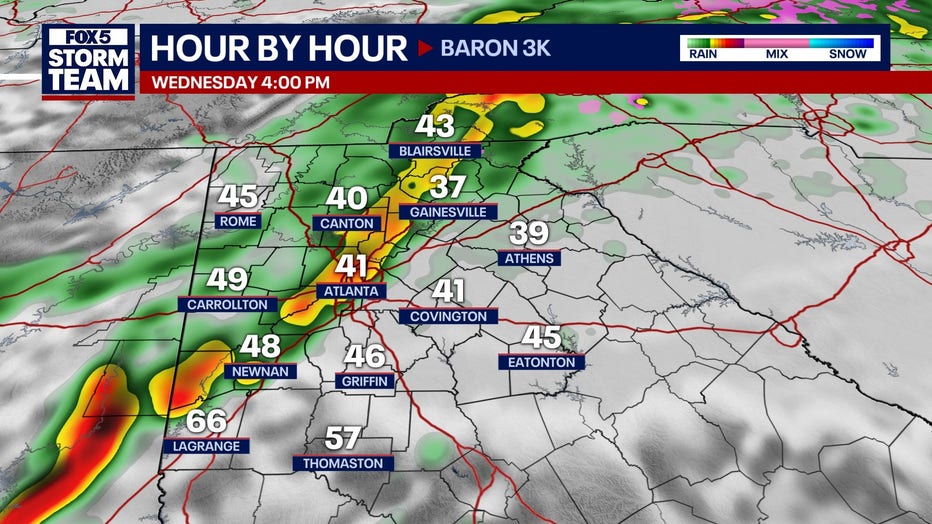
It's going to be a very wet day for most of metro Atlanta and North Georgia. Rain will be heavy at times and there is a risk of flooding.
ATLANTA - Residents in metro Atlanta woke up to a soggy Wednesday morning, with waves of steady rain expected to continue throughout the day.
This is just the beginning of a week filled with fluctuating temperatures and varying rain chances.
Flood Watch in North Georgia
What we know:
A Flood Watch has been issued and extended across numerous counties, including: Murray County, Forsyth County, Dade County, Douglas County, Pike County, Troup County, White County, Gilmer County, Spalding County, Haralson County, Pickens County, Gwinnett County, Heard County, Fayette County, Polk County, Whitfield County, Coweta County, Walton County, Carroll County, Catoosa County, Banks County, Meriwether County, Cobb County, South Fulton County, Chattooga County, Fannin County, Paulding County, Bartow County, Towns County, Floyd County, Jackson County, North Fulton County, Walker County, DeKalb County, Rockdale County, Union County, Newton County, Henry County, Cherokee County, Lumpkin County, Gordon County, Dawson County, Hall County, Clayton County, Barrow County, Clay County.
This watch is in effect from late Tuesday afternoon through Thursday morning.

What we don't know:
Rainfall totals are anticipated to range between three and five inches, with some areas potentially receiving up to seven inches. Residents near creeks, rivers, and other waterways should remain vigilant, as minor flooding is possible. Motorists are advised to exercise caution due to the likelihood of standing water on roadways.

Timeline:
While today's forecasted high for the metro area is 48 degrees, some locations could see significantly warmer temperatures. Cooler conditions will persist through much of the day, with milder weather expected to return on Thursday and through the weekend. However, another cooldown is forecasted after the weekend, bringing rain and storms by Presidents Day.
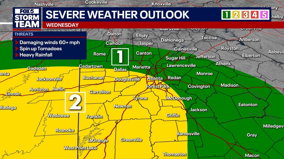
A severe weather risk looms for some areas, especially this evening, when a line of storms moving in from Alabama could bring gusty winds and potential thunderstorms. By 11 p.m., strong winds at the leading edge of the storms may impact parts of Georgia before moving out overnight. Most of the region should dry out by sunrise Thursday, though cloudy skies will linger before clearing into the afternoon.
Thursday and Friday will see more sunshine, including a dry Valentine’s Day on Friday, but the break from rain will be short-lived.
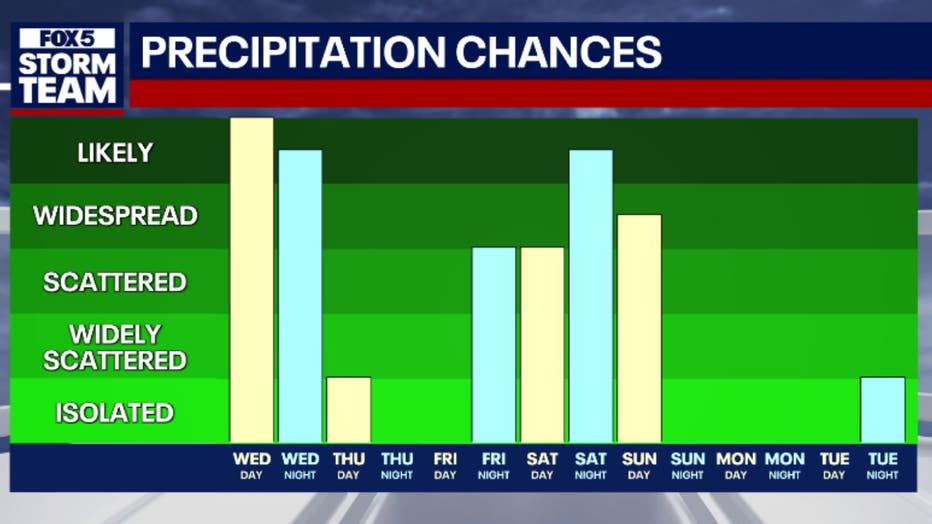
Another round of showers is expected Saturday, with scattered rain during daylight hours before stronger storms develop late Saturday night into early Sunday morning.
Fortunately, Sunday may not be a complete washout, as conditions could improve as the day progresses.

Looking ahead to Presidents Day on Monday, forecasters predict sunny and dry weather, offering a brief reprieve before the next weather system moves in.

The Source: This article is based on the original forecast of the FOX 5 Storm Team.