

Cloud cover and scattered Sunday showers
Sunday morning weather forecast
FOX 5 Storm Team Meteorologist Alex Forbes says a drying trend is on the way for the first week of June.
ATLANTA - Thick cloud cover and scattered rain showers will dominate the Atlanta weather forecast on Sunday afternoon as meteorologists track a shifting system ahead of a minor severe weather risk on Monday.
What we know:
Substantial cloud cover over Hartsfield-Jackson Atlanta International Airport is locking in cooler temperatures, making it a gloomy Sunday afternoon for outdoor activities.
Local radar shows a smattering of light, short-lived showers popping up along Highway 27 heading toward Newnan, alongside heavier downpours sliding through Oconee, Barrow and Greene counties. High temperatures on Sunday will struggle to get past the mid-to-upper 70s, though one or two spots across North Georgia might briefly hit 80 degrees.
Big picture view:
A distinct drying trend will begin early next week, with rain chances dropping to 30% on Monday and 20% on Tuesday. Temperatures through the back half of the week will remain seasonal, if not just slightly below average.
Sunday will be 5 to 10 degrees cooler than Saturday, carrying a predicted high of 75. While Sunday morning will start with a few early showers, the afternoon will turn predominantly cloudy with fewer storms than Saturday.
By the numbers:
- 4.54: The total inches of rainfall recorded officially at the Atlanta airport since May 22.
- 1: The visibility baseline in miles observed in Covington during the worst of Sunday's morning fog.
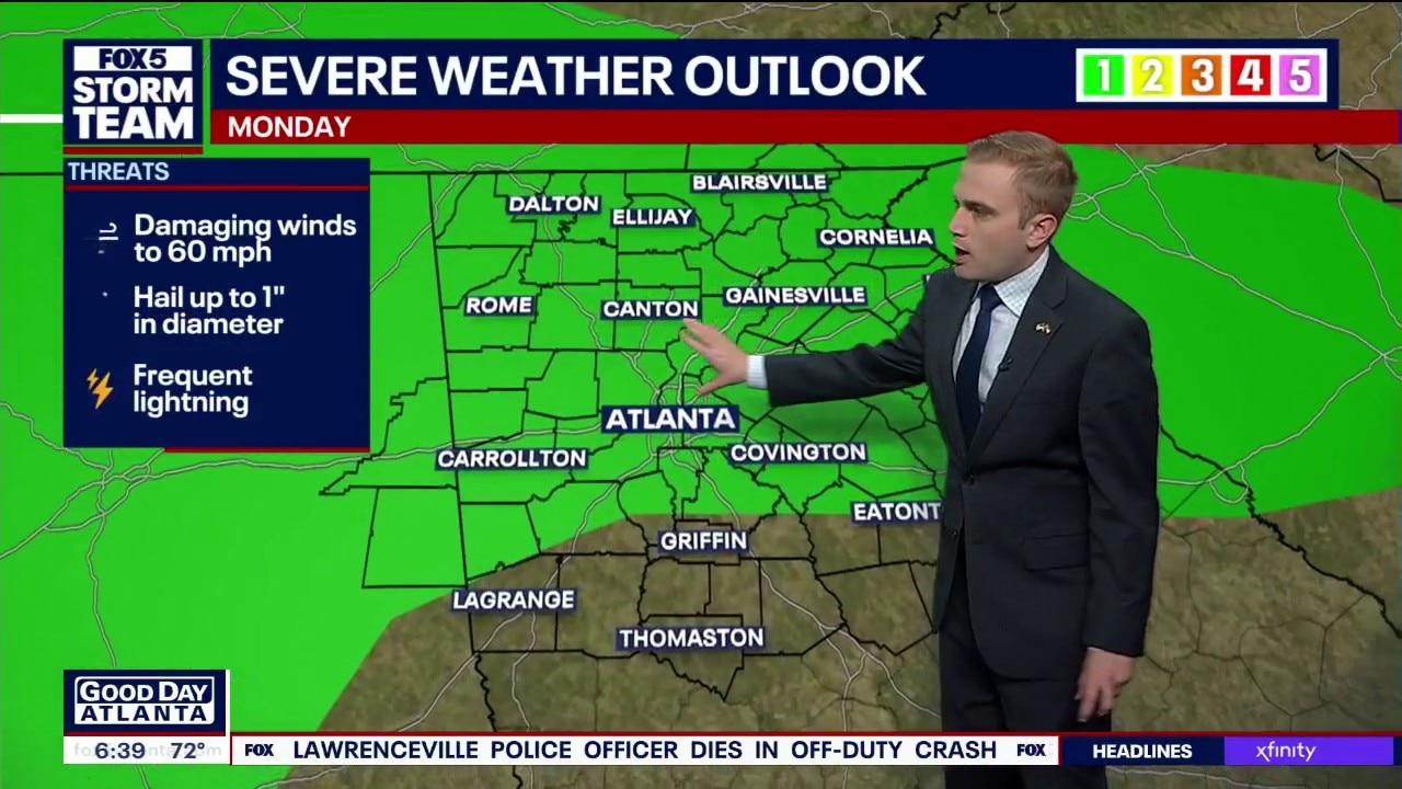
- 30: The percentage chance of rain and isolated severe storms forecast for Monday.
- 60: The critical dew point threshold that weather conditions will drop below from Wednesday through Saturday.
What's next:
The Storm Prediction Center placed a large section of North Georgia along and north of Interstate 20 under a Level 1 severe weather risk for Monday. A cluster of storms sliding south out of the Chattanooga area could bring isolated damaging wind gusts, though overall rain chances remain low at 30%. A refreshing drying trend will take over from Wednesday through Saturday, lowering dew points below 60 and delivering rare, dry June days with highs in the low 80s.
The Source: The information in this story was gathered from FOX 5 Storm Team meteorologist Laurann Robinson, who detailed the live radar tracking, temperature records, and local hazardous weather advisories from the station's weather center.