

Hurricane Isaias strengthens: North Georgia faces weekend storm threats
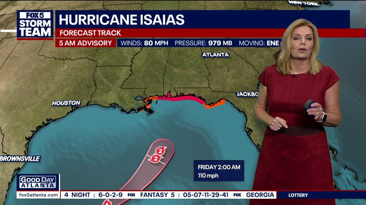
Hurricane Isaias strengthening as it approaches
Hurricane Isaias’ sustained winds increased to 80 mph in the latest update, up from 75 mph. The storm could approach major hurricane strength before reaching the Alabama coast or Florida Panhandle. North Georgia faces rain, strong winds and a tornado risk this weekend, especially Saturday.
ATLANTA - Hurricane Isaias strengthened early Thursday, and North Georgia remains in line for rain, strong winds and possible tornadoes this weekend, even with the storm’s center forecast to pass west of the area.
The National Hurricane Center’s 5 a.m. update put the Category 1 hurricane’s maximum sustained winds at 80 mph, up from 75 mph in the previous advisory.
What has changed?
What we know:
The latest forecast calls for Isaias to strengthen to a Category 2 hurricane with sustained winds near 110 mph by late Thursday into early Friday. That would put the storm near the threshold for Category 3 status, which is considered a major hurricane.
Further strengthening remains possible, according to the FOX 5 Storm Team Chief Meteorologist Joanne Feldman.
Isaias is expected to reach the Alabama Gulf Coast or portions of the Florida Panhandle late Friday into early Saturday, potentially as a Category 2 hurricane. It is forecast to weaken after moving inland.
PREVIOUS STORY
Isaias strengthened into a hurricane as of late Wednesday evening.
The Category 1 storm is charging through the Gulf of Mexico, heading for a northern Gulf Coast landfall late Friday before taking a track straight through Alabama and bringing rainy weather to the Southeast.
FOX 5 has issued Storm Alert Days for both Saturday and Sunday due to the persistent weather hazards.
Gulf Coast hurricane updates
What we know:
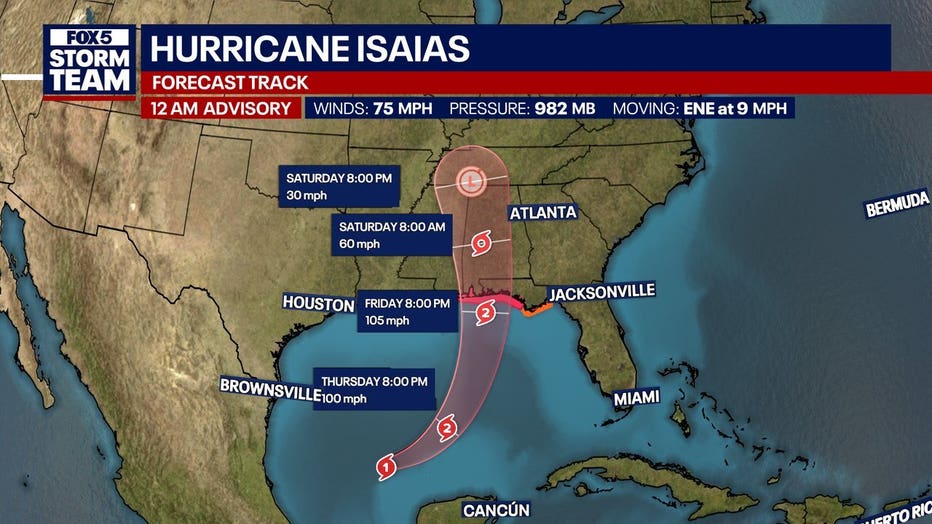
Hurricane Isaias is strengthening over warm, undisturbed waters in the Gulf of Mexico, with sustained winds reaching 70 mph as it moves east-northeast at 9 mph.
The National Hurricane Center forecasts the storm to reach Category 2 hurricane strength before making landfall late Friday night or early Saturday morning, targeting the western Florida Panhandle and the Alabama coastline.
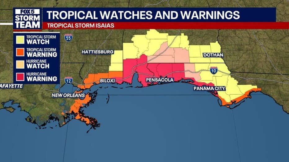
A Hurricane Warning stretches from Ocean Springs, Mississippi, to the Bay/Gulf County line in Florida. A Storm Surge Warning covers coastal areas from the mouth of the Mississippi River to Steinhatchee, Florida, where life-threatening inundation is expected.
A Hurricane Hunter aircraft found a rapidly strengthening system with a developing eye. Its central pressure has fallen to 982 mb.
As of midnight on Thursday, the hurricane was located about 460 miles south southwest of the mouth of the Mississippi River and moving east northeast at 9 mph. Isaias is forecast to continue strengthening as it heads toward the northern Gulf Coast late Friday night into early Saturday.
What we don't know:
While confidence in general weather impacts is high, meteorologists stress that the exact intensity and localized extent of the wind, flash flooding and tornado threats across specific North Georgia neighborhoods remain uncertain.
North Georgia weather impacts
Local perspective:
An updated forecast track shifted Isaias slightly westward, removing North Georgia from the storm's center track cone. However, FOX 5 Storm Team meteorologist Jonathan Stacey emphasized that local communities should not relax, as the region sits on the wetter, windier eastern side of the system.
Outer feeder bands will begin pushing into metro Atlanta by Friday afternoon, bringing long-duration gusty winds and heavy rain through Saturday as the system moves into the Tennessee Valley. Rain totals across the Southeast could range from 1 to 3 inches with localized amounts up to 5 inches, creating flash flooding and river flooding threats.
DOWNLOAD THE FOX LOCAL APP FOR THE LATEST FORECASTS
What's next:
FOX 5 has declared FOX 5 Storm Alert Days for Saturday and Sunday due to expected severe weather and travel disruptions. Residents planning outdoor activities this weekend are advised to establish alternate plans, though meteorologists suggest holding off on final cancellations until clearer forecast trends emerge Friday.
Georgia Bulldogs stormy game day in Tuscaloosa
Why you should care:
Georgia Bulldogs fans traveling to Tuscaloosa, Alabama, for Saturday night's showdown against the Crimson Tide should prepare for wet weather. Because the forecast track brings the weakening center of Isaias right through Alabama on Saturday, heavy rain and breezy conditions are expected around Bryant-Denny Stadium during game time.
What's next:
Travelers heading west along Interstate 20 toward Alabama on Saturday morning should anticipate heavy downpours, low visibility, and potential flash flooding on roadways. Fans planning to attend tailgates or the game should pack rain gear and monitor local weather updates closely.
7-day forecast
Timeline:
Here is the local forecast:
Metro Atlanta
- Tonight: Mostly clear with a low around 57 degrees.
- Thursday: Mostly sunny with a high near 87 degrees.
- Thursday Night: Mostly cloudy with a low around 62 degrees.
- Friday: Partly sunny with a high near 80 degrees; east winds 5 to 10 mph with gusts up to 20 mph.
- Friday Night: Mostly cloudy with a low around 61 degrees; 40% chance of showers mainly after 2 a.m. and east wind gusts up to 25 mph.
- Saturday: 80% chance of showers and thunderstorms with a high near 73 degrees.
- Saturday Night: 90% chance of showers and thunderstorms with a low around 62 degrees.
- Sunday: 60% chance of showers mainly before 8 a.m., becoming partly sunny with a high near 79 degrees.
- Sunday Night: Partly cloudy with a low around 61 degrees.
- Monday: Mostly sunny with a high near 82 degrees.
- Monday Night: Mostly clear with a low around 61 degrees.
- Tuesday: Sunny with a high near 84 degrees.
- Tuesday Night: Mostly clear with a low around 59 degrees.
- Wednesday: Sunny with a high near 79 degrees.
North Georgia mountains
- Tonight: Mostly clear with a low around 52 degrees.
- Thursday: Sunny with a high near 80 degrees.
- Thursday Night: Partly cloudy with a low around 55 degrees.
- Friday: Mostly sunny with a high near 76 degrees.
- Friday Night: Mostly cloudy with a low around 57 degrees; 30% chance of showers after 2 a.m. with wind gusts up to 15 mph.
- Saturday: 60% chance of showers and afternoon thunderstorms with a high near 68 degrees.
- Saturday Night: 90% chance of showers and thunderstorms with a low around 58 degrees.
- Sunday: 50% chance of showers with a high near 70 degrees.
- Sunday Night: 20% chance of showers before 2 a.m. with a low around 57 degrees.
- Monday: Mostly sunny with a high near 73 degrees.
- Monday Night: Partly cloudy with a low around 54 degrees.
- Tuesday: Sunny with a high near 76 degrees.
- Tuesday Night: Mostly clear with a low around 51 degrees.
- Wednesday: Sunny with a high near 73 degrees.
The Source: The information in this story was gathered from the National Hurricane Center and a broadcast weather update by the FOX 5 Storm Team. This story has been continuously updated throughout the day when new data is released and forecasts are refined.