

Atlanta weather: Stalled front to bring warmer temps, increased rain chance this week

Easter Day forecast
Showers and storms return for this coming work week. Here's the latest from the FOX 5 Storm Team.
ATLANTA - Above-average temperatures and increasing rain chances are expected across North Georgia through the coming week as a stalled front lingers over the region.
Temperatures on Sunday climbed into the mid-80s across much of the area under partly cloudy skies, setting the stage for a warm and unsettled pattern over the next several days.
KEEP UP WITH THE LATEST BY DOWNLOADING THE FREE FOX 5 STORM TEAM APP AND FOLLOWING @FOX5STORMTEAM ON X, FORMERLY TWITTER
A warm Easter Sunday
What they're saying:
"All the Easter egg hunts going on, it's happening under a warming note," FOX 5 Storm Team meteorologist Alex Forbes said. "If you did your hunt at, like, 8:00 this morning, it was in the 60s. Well, now, here we are at noon and it's 74 with a mix of clouds across the area."
Showers and thunderstorms associated with a strong system over Arkansas and Missouri will lose strength as they move east, but cloud cover and moisture will remain. The front is expected to stall over north Georgia by Monday afternoon, leading to a steady chance of showers and storms throughout the week.
"For the remainder of today, it's going to be a cloudy one, also a warm one," Forbes said. "Temperatures in the mid to upper 80s at times — 84 here in the city — winds out of the south-southeast at about 5 to 10 [mph]."
Will it rain this week?
Dig deeper:
Rain chances increase Monday afternoon and evening, primarily in far north Georgia. Scattered showers could reach the Atlanta metro area overnight into Tuesday morning, with additional rounds possible through midweek. Severe weather is not anticipated, but isolated storms could produce occasional lightning.
"Tomorrow afternoon and evening, some scattered storms [are] arriving in parts of northwest Georgia," Forbes said. "Some of those [storms] could even include a storm with maybe even a couple strikes of lightning."
Daily high temperatures will remain well above normal, generally in the low-to-mid 80s, while overnight lows stay in the 60s. Typical highs for this time of year are around 75 degrees.
"The front pushes in and stalls out and really falls apart," Forbes said. "But as it does so, it is going to prompt showers and storms each day through next weekend."
Forbes projects that the stalled boundary will bring near-daily rain chances of around 30% to 50%, especially during afternoon and evening hours. Forecast models show a quasi-zonal pattern setting up, meaning weak disturbances will occasionally trigger showers but without widespread coverage.
Atlanta forecast
What's next:
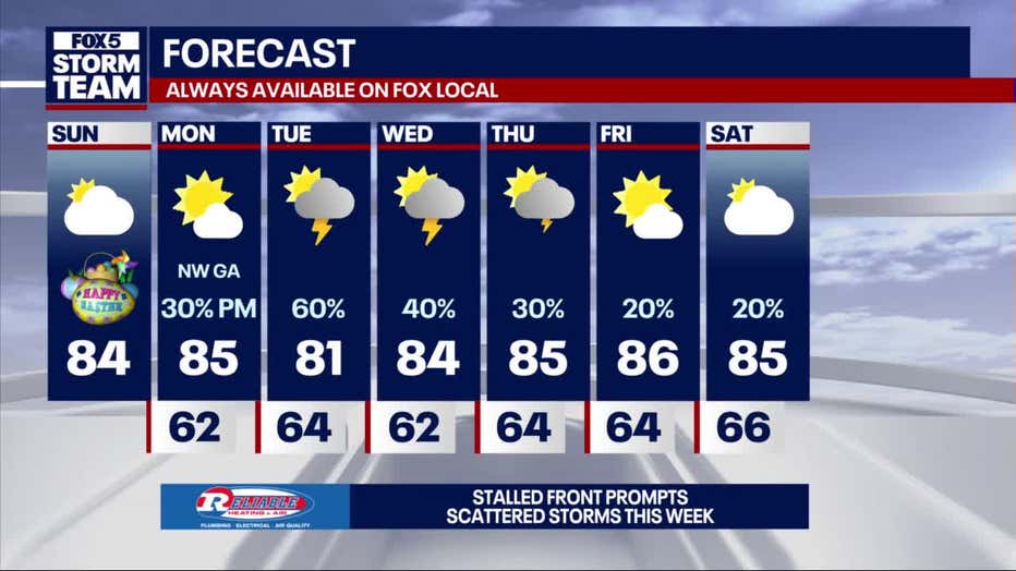
Forecast Highlights:
- Monday: High near 85 in Atlanta, with a 30% chance of evening showers and storms.
- Tuesday: High around 81, with scattered showers and a 50% chance of thunderstorms, mainly after 2 p.m.
- Wednesday-Friday: Partly sunny each day with isolated to scattered afternoon showers and storms. Highs in the mid-80s, reaching up to 88 by Friday.
- Saturday: Rain chances remain near 30% with highs in the upper 80s.
Northwest and extreme North Georgia will see slightly cooler temperatures early in the week and higher rain chances, particularly Monday night into Tuesday.
The Source: This article contains the original forecast by the FOX 5 Storm Team.