

Atlanta and North Georgia dealing with icy, slushy roadways from winter storm
Saturday night temperatures dip below freezing
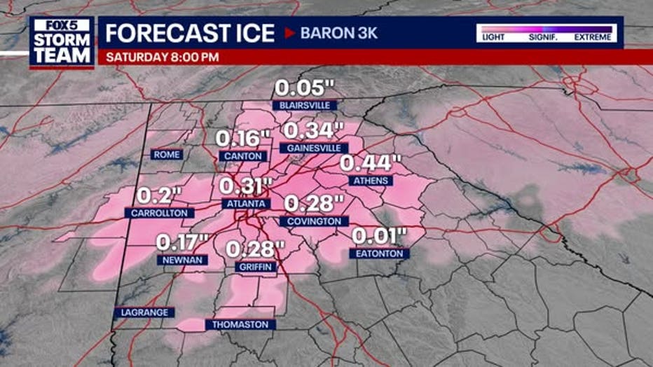
Here's the latest forecast across metro Atlanta and North Georgia with FOX 5 Storm Team Meteorologist Laurann Robinson.
ATLANTA - Winter weather gripped North Georgia on Friday, leaving behind snow, ice, and treacherous road conditions. As temperatures continued to plummet Saturday night, freezing rain and refreeze on roads posed significant hazards, closing out the weekend.
FOX 5 Storm Team Meteorologist Laurann Robinson says most of the main roads appear to be pretty clear, but lesser traveled areas may still have some slush on the roads.
LIVE UPDATES: CLOSINGS AND DELAYS
Winter storm | Tracking road conditions 7 a.m. update
The FOX 5 Storm Chaser is out on the roads monitoring conditions.
Waking up to icy, slushy roadways
While precipitation had largely ended Friday night, forecasters warned that icy conditions and high winds would continue to pose challenges through Saturday.
Icy roadways were the main concern, especially in areas that briefly rose above freezing earlier that day. The combination of freezing temperatures and gusty winds also increased the risk of power outages as ice-coated tree limbs and branches fell.
"Temperatures are a degree or two below freezing in some areas, and a degree or two above in others," said a meteorologist monitoring the situation Friday night. "More importantly, winds have increased, potentially causing more trees and branches to come down under the weight of the ice."
In fact, a Marietta woman told FOX 5 Atlanta she was watching television in her bedroom when a tree suddenly came crashing down onto her home, sending branches through the ceiling.
Icy tree branches pierce through roof
Georgia Power has restored service to most metro Atlanta homes that lost it during the winter storm. Now, residents are dealing with a new hazardous: falling tree limbs. One woman told FOX 5 Atlanta she was watching television at home when a tree came crashing through her roof.
"I heard a noise and a crack, and I thought it was kind of like the ice or the snow falling from the roof. The next second, the branches came through the roof. It was kind of like the whole room went white. There was debris everywhere," said Emma Fulloon. "I couldn't tell what was happening, or if more was happening, but it happened just so quickly."
The tree also damaged Fulloon's chimney, but she said she was grateful it wasn't any worse. It appears her family will be able to remain in their home, despite the damage.
Just before 8 p.m., the City of Atlanta announced Georgia Power had restored service to 97% of customers who lost power during the storm.
"Atlanta currently has 240 outages that should be restored by midnight," a spokesperson for the city said.
Things appeared to be calming down in Forsyth County, as well, where the county's Emergency Management Agency & 911 canceled the Emergency Operations Center that had been in place during Friday's heavy precipitation. Meanwhile, the Forysth County Government continued urging motorists to stay off the potentially icy roads.
Cobb County government also cautioned its residents about hazardous road conditions on Saturday, and said that its facilities, including parks and libraries, would remain closed for the day.
MARTA resumes bus service
Limited bus service by MARTA resumed Saturday evening. Drivers picked up the following "essential routes":
- 8 North Druid Hills Road
- 19 Clairmont/ W. Howard Avenue
- 40 Peachtree Street / Downtown
- 110 Peachtree Road/ Buckhead
- 111 Snapfinger Woods
- 123 Church Street
- 196 Upper Riverdale
Rail service is currently operating on a weekend schedule and mobility service will operate in emergency situations only as conditions allow.
Streetcar service is still suspended.
Real-time service information can be found on MARTA's social media accounts – @MARTAservice and @MARTAtransit on X (Twitter) and @MARTAtransit on Facebook.
How much snow fell in Atlanta?
The storm brought 1 to 5 inches of snow across North Georgia earlier in the day, with 3 inches recorded at FOX 5 studios in Atlanta. Officially at Hartsfield-Jackson, Atlanta recorded 2.1 inches of snow.
How much snow in Atlanta?: Preliminary snowfall totals from North Georgia
The snowstorm delivered varied totals across the metro area, with 1 to 3 inches on the east and west sides and up to 4 inches in Carrollton and Greene County. Ice accumulations also created issues, with up to a quarter-inch of ice in parts of metro Atlanta and isolated heavier amounts along I-85. "That ice is hanging on trees and power lines, and with winds picking up, power outages are rising," Chandley explained.
Black ice and refreezing
Chandley noted road temperatures across the region were hovering around freezing. "Even areas slightly above freezing are hazardous, and we urge drivers to remain cautious," she said.
Chandley warned of worsening conditions as strong winds, gusting up to 25 mph, could bring more power outages on Saturday. The extended forecast showed temperatures dipping into the teens and lower 20s from Saturday night into Sunday morning. "It’s bone-chilling cold," Chandley said. "The freezing temperatures and icy roads make for a storm alert day tomorrow, even without additional precipitation."
Beware of black ice Saturday morning
First responders are urging motorists to stay home on Saturday due to the potential for black ice. What is black ice? It's a thin, layer of ice that is very difficult to see. It can form on roads, sidewalks and driveways in freezing conditions. Since it's nearly invisible, it poses a huge risk to drivers and pedestrians.
Forecasters urged residents to stay off the roads if possible. Limited melting is expected on Saturday, with highs in the mid-30s before temperatures drop again.
"This is a dangerous situation," Chandler said. "Stay safe and stay tuned for updates as we navigate this winter weather event."
Even colder Sunday
By Sunday morning, widespread temperatures in the teens will blanket North Georgia, though the cold air is not expected to linger all day. Forecasters predict a warming trend in the afternoons, with temperatures reaching the 40s by Sunday and remaining there throughout the week.
"This storm started as sleet and quickly changed over to snow," the meteorologist said. "The snow was beautiful, and while the ice on tree branches might look picturesque, it has caused significant problems for power lines and road safety."
As of Saturday, residents are advised to remain cautious while driving, especially during early morning hours when ice is most likely to persist. For those without power, the increase in winds and dropping temperatures could pose additional challenges.
The next few days will bring cold mornings but milder afternoons, offering some relief from the harsh conditions brought by the storm.
Keep up with the latest by downloading the FREE FOX 5 Storm Team app and following @FOX5StormTeam on Twitter
The Source: This is an original weather report by FOX 5 Storm Team Meteorologist Alex Forbes.